TOWARDS THE IMPLEMENTATION OF A GEOTECHNICAL ASSET MANAGEMENT PROGRAM IN THE STATE OF GEORGIA.
PI: Jorge Macedo
Co-PI(s): Susan Burns
Institution(s): Georgia Institute of Technology
Abstract
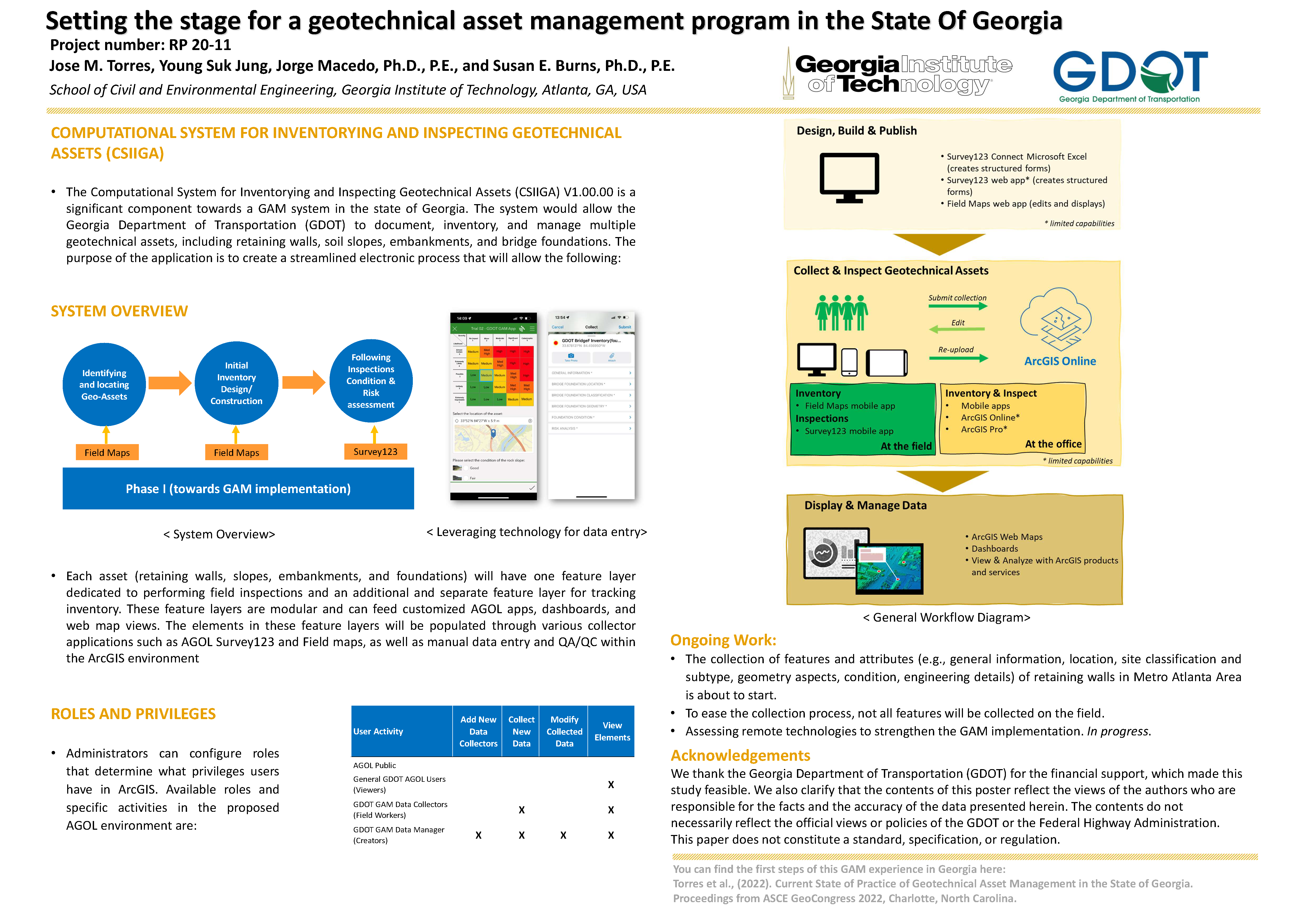
This poster portrays the Computational System for Inventorying and Inspecting Geotechnical Assets (CSIIGA) as a significant component towards a GAM program in the state of Georgia. The system would allow the Georgia Department of Transportation (GDOT) to document, inventory, and manage multiple geotechnical assets, including retaining walls, soil slopes, embankments, and bridge foundations.
Please comment below with any statements or questions you may have. Also let GTI if you would be interested webinars or presentations on similar topics.
INCORPORATING RESILIENCE CAPABILITIES INTO LONG-RANGE TRANSPORTATION PLANS: FLEXIBILITY AND AGILITY
PI: Adjo Amekudzi-Kennedy
Co-PI(s):
Institution(s): Georgia Institute of Technology
Abstract
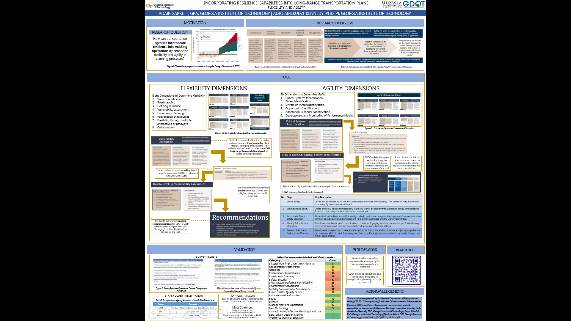
Transportation systems are key to supporting the safety and mobility of urban and rural populations and are part of overall infrastructure systems that also include water facilities, electricity and power plants, communication networks, and others. These vital systems are affected by changes to the environment, political systems, and technological landscapes in which they operate. Recently, COVID-19 showed that there are unknown threats that can disrupt infrastructure planning, funding, design, construction, usage, and many other critical components of transportation systems. Simultaneously, transportation planners are faced with changing conditions due to increasing frequency of extreme weather events, varying demands from increasingly diverse populations, and shifting funding needs and sources. The dynamic conditions and emerging complex challenges will impact the way that agencies write and design their long-range transportation plans (LRTPs). Flexibility and agility are qualities that have emerged in the literature as ways to increase resilience in transportation planning, but there are currently no formalized pathways for incorporating flexibility and agility into long-range transportation planning. This research creates a framework for organizations to adopt these qualities into their planning processes. This research develops a tool to easily incorporate these qualities into LRTP development and evaluates GDOT?s Statewide Strategic Transportation Plan from 2021 for gaps and opportunities to increase flexibility and agility. Based on the evaluation, specific recommendations are provided to GDOT to support the development of these capabilities.
Please comment below with any statements or questions you may have. Also let GTI if you would be interested webinars or presentations on similar topics.
INCORPORATING ACCESSIBILITY INTO VULNERABILITY ASSESSMENTS FOR ENHANCED EQUITY AND RESILIENCE
PI: Adjo Amekudzi-Kennedy
Co-PI(s):
Institution(s): Georgia Institute of Technology
Abstract
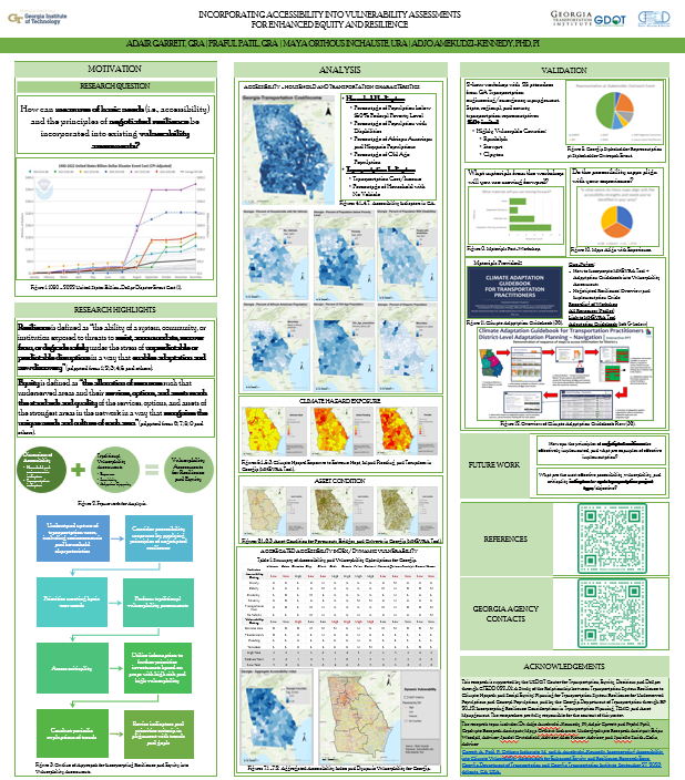
Transportation systems are key to serving the basic needs of society. These critical systems are impacted by increasing frequency of disasters, aging infrastructure, and changing social demands. Vulnerability assessments examining exposure, sensitivity, and adaptive capacity are factors of transportation resilience that reflect the ability of infrastructure to withstand, adapt to, and respond to disruptions. At the same time, there are basic standards for transportation that are often captured by accessibility measures. These standards are a contributing factor to enhancing community resilience, but they are often considered separately from transportation resilience analysis. Ensuring that accessibility standards are met before implementing other projects can reduce the vulnerability of transportation users and the system at large, thus enhancing long-term system resilience. Applying the principles of negotiated resilience may enable agencies to address more effectively emerging demands and competing priorities for all stakeholders. This research first provides a clear prioritization pathway that accounts for vulnerability and accessibility indicators. From there, we provide an analysis exploring relevant indicators for each of these concepts for the state of Georgia. A stakeholder outreach event and workshop focused on transportation practitioners and emergency managers in Georgia enabled us to validate our analysis and gain more insight into the current state of practice concerning vulnerability assessment and adaptation. This workshop was designed to incorporate and apply emerging theory regarding negotiated resilience. This research develops and demonstrates a framework for conducting future vulnerability assessments that reflect the basic transportation needs of communities in addition to the vulnerability of physical infrastructure.
Please comment below with any statements or questions you may have. Also let GTI if you would be interested webinars or presentations on similar topics.
MULTI-HAZARDS EXPOSURE, VULNERABILITY AND RISK ASSESSMENT: BUILDING CLIMATE RESILIENCE WITH THE MHEVRA TOOL
PI: Adjo Amekudzi-Kennedy
Co-PI(s):
Institution(s): Georgia Institute of Technology
Abstract
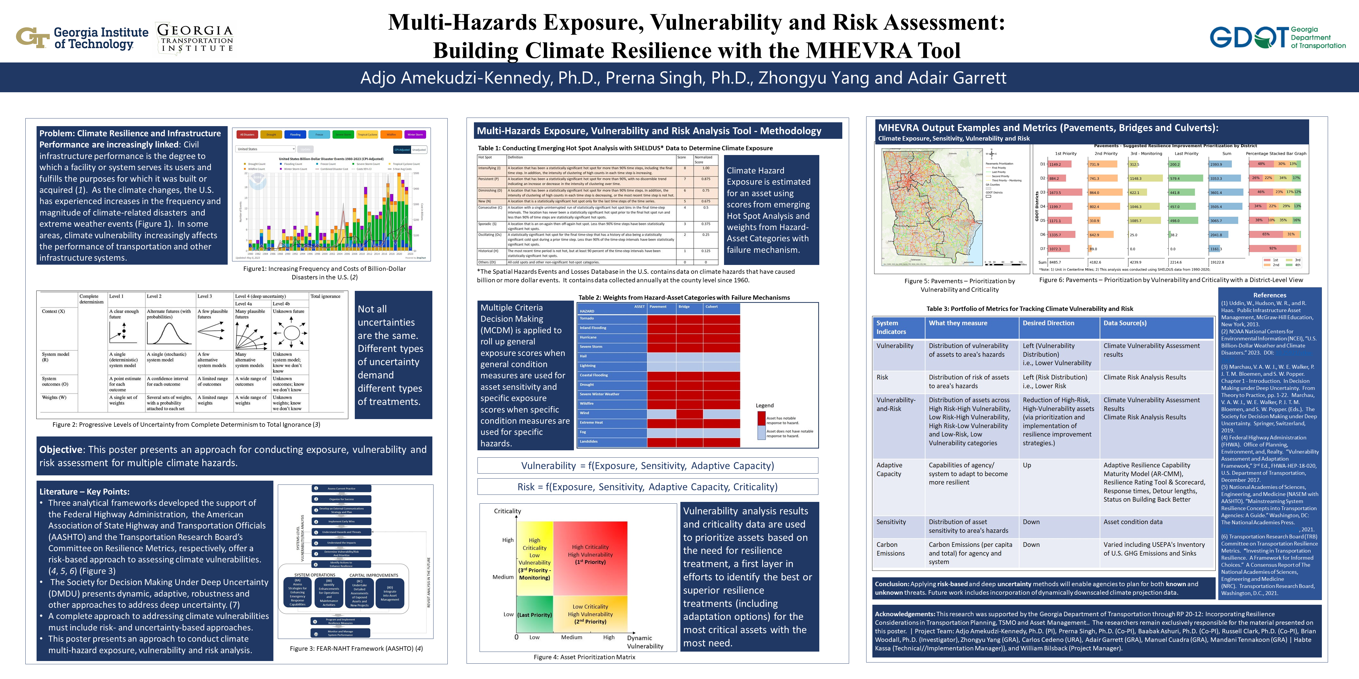
Resilience building capabilities are becoming increasingly essential components of performance management systems for transportation and other infrastructure agencies. The United States? Infrastructure Investment and Jobs Act incentivizes transportation and other infrastructure agencies to prioritize investments to strengthen resilience to climate-related disruptions. Developing these capabilities will enable agencies to understand better how their systems are exposed to different hazards and provide the information necessary for prioritizing their assets and systems for resilience improvement. This paper discusses an approach to resilience building to known and unknown climate-related threats and extreme events in a transportation agency. It leverages long-term climate hazard databases, spatial and statistical analyses, and non-probabilistic approaches for specific and general climate resilience improvement. The approach was developed as part of a research project to create climate resilience building capabilities for the Georgia Department of Transportation. The study highlights the importance of good multiscalar data for addressing both specific and general resilience. It also highlights the importance of infrastructure and organizational resilience in creating robust approaches to building resilience in transportation systems. The paper is of potential value to practitioners and researchers interested in developing resilience building capabilities to manage the effects of climate-related hazards and extreme events as well as unknown threats on infrastructure and organizational performance.
Please comment below with any statements or questions you may have. Also let GTI if you would be interested webinars or presentations on similar topics.
HARMONIZING CLIMATE ADAPTATION PLANNING FOR TRANSPORTATION SYSTEM RESILIENCE ? DEVELOPMENT OF AN ADAPTATION GUIDEBOOK FOR TRANSPORTATION
PI: Adjo Amekudzi-Kennedy
Co-PI(s):
Institution(s): Georgia Institute of Technology
Abstract
Developing long-term transportation plans is vital for the allocation of funds, project prioritization, maintenance scheduling, and preparation for potential future challenges, such as urban development and population changes. Nevertheless, decision-makers are finding it progressively more complex and demanding to devise long-term transportation plans due to the profound uncertainty of what lies ahead. Furthermore, as crucial systems like transportation become more interconnected, there is a higher possibility of catastrophic and unexpected hazards threatening systems with more frequency and intensity. Climate change-induced disasters pose a significant threat to vulnerable transportation systems worldwide. This thesis proposes an approach to integrate adaptation planning in disaster risk reduction through the development of an adaptation guidebook. The guidebook aims to support local communities and policymakers in identifying and addressing the climate risks and impacts. The objective of this writing is to discuss emerging adaptation frameworks, review adaptation strategies for transportation assets and propose a Climate Adaptation Guidebook for Transportation including context specific adaption measures for different districts in a state Department of Transportation using Georgia Department of Transportation as the case study ? to address adaptation consequences of climate change related events to transportation systems.
Please comment below with any statements or questions you may have. Also let GTI if you would be interested webinars or presentations on similar topics.
UNCERTAINTY PLANNING: RESILIENCE WITH IMPERFECT KNOWLEDGE
PI: Adjo Amekudzi-Kennedy
Co-PI(s): Baabak Ashuri, Russell Clark, and Brain Woodall
Institution(s): Georgia Institute of Technology
Abstract
Decision Making Under Deep Uncertainty (DMDU) enables decision makers to better incorporate risk into planning and decision making to exploit opportunities and mitigate risks. DMDU, however, is an emerging field with little maturity in its application to resilience building and resilient operations. As such, this project aimed to formulate a framework of three methods for planning and operating resilient transportation infrastructure systems on multiple levels of governance. A case study on the Talmadge Memorial Bridge describes a situation of deep uncertainty that benefits from the decision-making methods.
Please comment below with any statements or questions you may have. Also let GTI if you would be interested webinars or presentations on similar topics.
COMMUNITY-AUGMENTED RAPID-RESPONSE TO EVENTS (CARE) INTEGRATED CRISIS COMMUNICATION SYSTEM
PI: John E. Taylor
Co-PI(s): Neda Mohammadi
Institution(s): Georgia Institute of Technology
Abstract
The objective of this project is to establish a crisis rapid-response communication system, which is augmented with location-specific social and community data, and integrated with current GDOT crisis identification and response communication processes. This will be achieved through development of a system that leverages social and community data for detecting, validating, and more effectively communicating specific routine or emergency events. The system development and integration proposed in this project aims to supplement current GDOT crisis identification and response management systems in place in terms of speed, coverage, effectiveness, efficiency, situational awareness, and inclusiveness, and support day-to-day decision making and response operations, as well as state of emergency events and long-term planning. A central focus of this specific three year project will be to examine ongoing events occurring in Georgia with augmented social and community data.
Please comment below with any statements or questions you may have. Also let GTI if you would be interested webinars or presentations on similar topics.
SATELLITE IMAGE AND REMOTE SENSING ANALYSIS FOR HIGHWAY ASSET MANAGEMENT
PI: S. Sonny Kim
Co-PI(s): Stephan Durham, Mi Chorzepa, Jidong James Yang, and Deepak Mishra
Institution(s): University of Georgia
Abstract
Pavement condition assessment is commonly performed using information about rideability, structure, surface distress and skid resistance. In spite of the long-lasting contribution of conventional road monitoring methods, these methods require data collected from in-situ inspection. Due to the extensive road network in the US, these approaches are not capable of monitoring all the roadways. On the other hand, remote sensing methods can play a significant role to complement conventional methods. Remote sensing methods use electromagnetic radiations in a wide range of wavelengths to collect information about various objects. Satellite imagery, as one of the cutting edge methods of remote sensing, utilizes the visible and infrared range of the electromagnetic spectrum to collect images with multiple bands. It has been seen in the literature that asphalt pavements have lower mean in reflectance values than concrete pavements. Also, as asphalt pavements age, reflectance values increase. Thus, this research investigates the application of free and available satellite images for monitoring road conditions.
Please comment below with any statements or questions you may have. Also let GTI if you would be interested webinars or presentations on similar topics.
CLUSTERING ANALYSIS OF PERMANENT COUNT SITES TO ENHANCE DATA ACCURACY THROUGH IMPROVED QUALITY CONTROL RULES
PI: Jidong J Yang
Co-PI(s): Stephan Durham, Sonny Kim, and Mi Geum Chorzepa
Institution(s): University of Georgia
Abstract
Data quality assurance is a critical component of statewide traffic monitoring programs. The current state of the practice uses quality control rules and examine data at each count station individually, which may not be robust since it disregards inherent dependency of stations in close vicinity. This research study aims to identify groups or clusters of continuous count stations (CCS) that are spatiotemporally correlated and leverage such correlations to improve the quality control of traffic data in support of various planning and engineering practices and decision-making at GDOT.
Please comment below with any statements or questions you may have. Also let GTI if you would be interested webinars or presentations on similar topics.
STRATEGIC PRIORITIZATION IN BRIDGE ASSET MAINTENANCE THROUGH DATA DRIVEN LONG-TERM ASSET VALUATION WITH ADDITIONAL EMPHASIS ON PROMOTING GDOT’S PARTNERSHIPS WITH COUNTIES
PI: Mi G. Chorzepa
Co-PI(s): Stephan Durham
Institution(s): University of Georgia
Abstract
The purpose of this project is to find ways to optimize bridge and transportation asset management and maintenance in the state of Georgia. This will be accomplished in a multitude of ways, but this project looks to bridge the gap in resources and knowledge between not only GDOT and local counties, but also among the counties themselves. To do this, this team will be developing an inspection guide, a resource guide, and an asset life-cycle analysis plan. Bridging the resource and knowledge gap between GDOT and local governments, as well as county to county, will go a long way towards fixing the divide between the conditions of state-owned transportation assets and local transportation assets.
Please comment below with any statements or questions you may have. Also let GTI if you would be interested webinars or presentations on similar topics.