RECOMMENDATIONS FOR NDT OF CONCRETE COMPONENTS FOR PERFORMANCE-BASED SPECIFICATIONS
PI: Laurence Jacobs
Co-PI(s): Kim Kurtis, Ryan Sherman, Jin-Yeon Kim and Jianmin Qu
Institution(s): Georgia Institute of Technology
Abstract
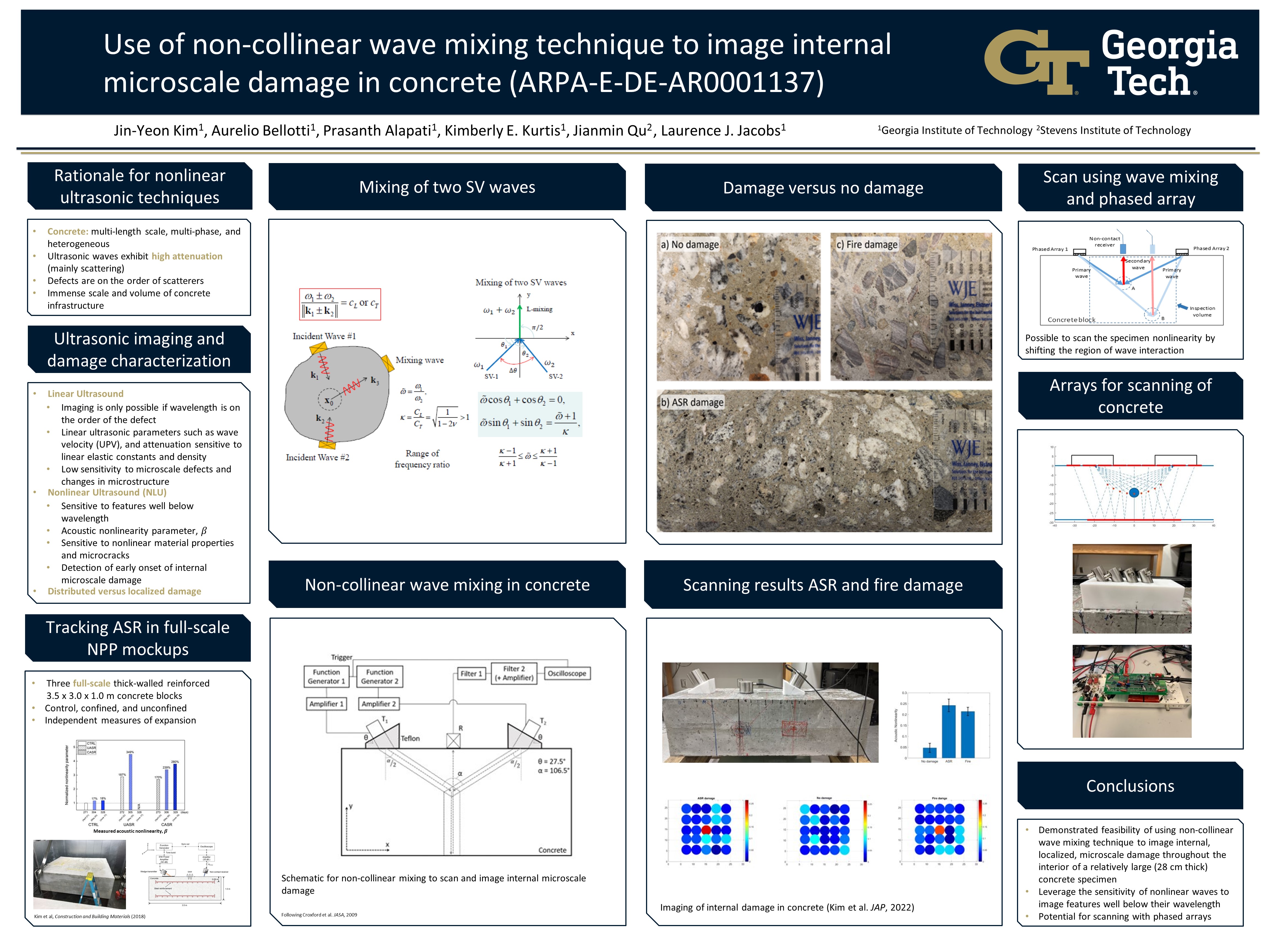
This poster demonstrates the feasibility of using a non-collinear wave mixing technique to image internal microscale damage throughout the interior volume of a relatively large (28 cm thick) concrete component. Unlike metals, concrete is rather heterogeneous with inherent microstructural features ranging in length from nanometers to millimeters or even centimeters. Many damage features that may significantly reduce the concrete material’s integrity are also within this range of length scales. This multiphase, heterogeneous, and multiscale nature of concrete makes the development of linear ultrasound based NDE and monitoring techniques for concrete technically challenging. Successful imaging using ultrasound requires that the ultrasonic wavelength be on the order of a few millimeters, yet the inherent length scale of this heterogeneous material with its fine and coarse aggregates is on this same millimeter length scale and larger. By exploiting the underlying mechanics of nonlinear wave mixing, this research shows it is possible to mix two incident waves with frequencies low enough to propagate without being scattered by the inherently heterogenous, concrete microstructure, while still being sensitive to damage features with length scales well below these incident wavelengths. Scanning and imaging is accomplished by manually adjusting the locations of the two incident waves, while knowledge of the wave speeds in concrete plus synchronization identifies the location of the mixing zone – the specific volume of concrete being imaged. The viability of the proposed technique is demonstrated by examining a concrete prism specimen with known, embedded internal microscale damage.
Please comment below with any statements or questions you may have. Also let GTI if you would be interested webinars or presentations on similar topics.
GUIDELINES FOR INCORPORATION OF CEMENT STABILIZED RECLAIMED BASE (CSRB) IN PAVEMENT DESIGN
PI: Jayhyun Kwon
Co-PI(s): Youngguk Seo
Institution(s): Kennesaw State University
Abstract
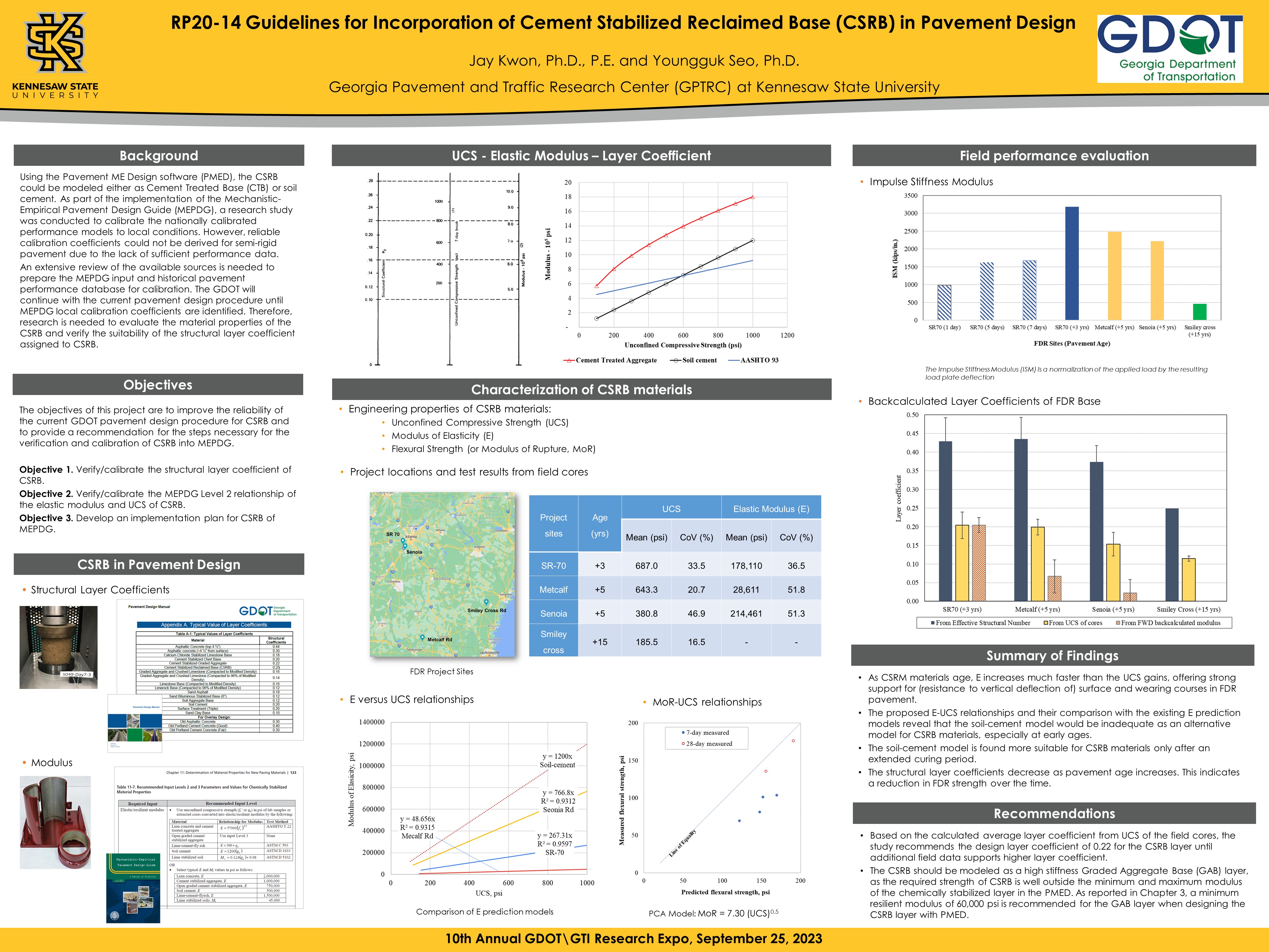
GDOT is in the process of implementing an updated Mechanistic-Empirical Pavement Design Guide (MEPDG). To support this implementation, a research study was conducted to calibrate the national performance models for local conditions. However, reliable calibration coefficients could not be derived for semi-rigid pavements due to the lack of sufficient performance data. GDOT will therefore continue to utilize the current pavement design procedure (AASHTO 72/93) until appropriate MEPDG local calibration coefficients have been identified. This research project was undertaken to improve the reliability of the current GDOT pavement design procedure for CSRB and to provide recommendations regarding the steps required to verify and calibrate CSRB for use in MEPDG. A preliminary laboratory study of typical CSRB mix and field cores was conducted to characterize the CSRB materials and evaluate the accuracy of the relationship between elastic modulus and unconfined compressive strength, after which performance data was collected for samples from 4 different sites in Georgia. The FWD deflection data and UCS values of the field cores were then used to calculate the structural layer coefficient of the CSRB layer and a sensitivity analysis was performed to identify the input variables with the greatest influence on the performance predicted by the PMED. Two different pavement types were used to model the FDR pavement: flexible pavement and semi-rigid pavement. Finally, a data collection plan was developed to guide the collection of the data needed for local calibrations of the MEPDG for roads in Georgia.
Please comment below with any statements or questions you may have. Also let GTI if you would be interested webinars or presentations on similar topics.
REAL-TIME NETWORK ASSESSMENT AND UPDATING USING VEHICLE-LOCATING DATA
PI: Iris Tien
Co-PI(s): Zachary Roberts
Institution(s): Georgia Institute of Technology
Abstract
Road infrastructure makes up a crucial component of Georgia’s asset network. Throughout the state, connections link different areas to each other, providing access to employment, social, and health services, thereby stimulating economic development. Halting these services are the presence of road blockages, including vehicular accidents, debris, flooding, which limit/prohibit travel along reported routes. Real-time traffic information needs to be collected and processed to ensure timely maintenance and hazard minimization. As most past studies have focused on stationary sources for real-time network analysis1 (e.g., loop detectors and traffic cameras), this study will utilize the wider-reaching and lower operational costing mobile sources of GDOT employee vehicles. Our network analysis will draw from three sources of data provided by GDOT (seen below in Figures 1-3, respectively): Georgia Network Database, WebEOC Executive Report, and the Verizon Network Fleet Database. The Georgia Network Database consists of a series of interconnected polylines representing the midpoint of Georgia roads. The WebEOC Executive Report is a large .csv file with the state route location, incident description, and the number of lanes passable. With processing, the data is converted into a usable ArcGIS Shapefile (.shp). The GDOT Verizon Network Fleet Geodatabase is a converted .csv of GDOT vehicle tracking information, including Vehicle ID, location, time, and ignition status of the vehicle (On/Off). Vehicles will be tracked with the same IDs in increments of 2 minutes to create vehicle route segments for further analysis.
Please comment below with any statements or questions you may have. Also let GTI if you would be interested webinars or presentations on similar topics.
USE OF GROUND PENETRATING RADAR TECHNOLOGY TO ASSESS AND MONITOR PAVEMENT STRUCTURAL CONDITIONS FOR IMPROVED PAVEMENT MAINTENANCE AND REHABILITATION STRATEGIES
PI: S. Sonny Kim
Co-PI(s): Stephan A. Durham, Jidong J. Yang
Institution(s): University of Georgia
Abstract
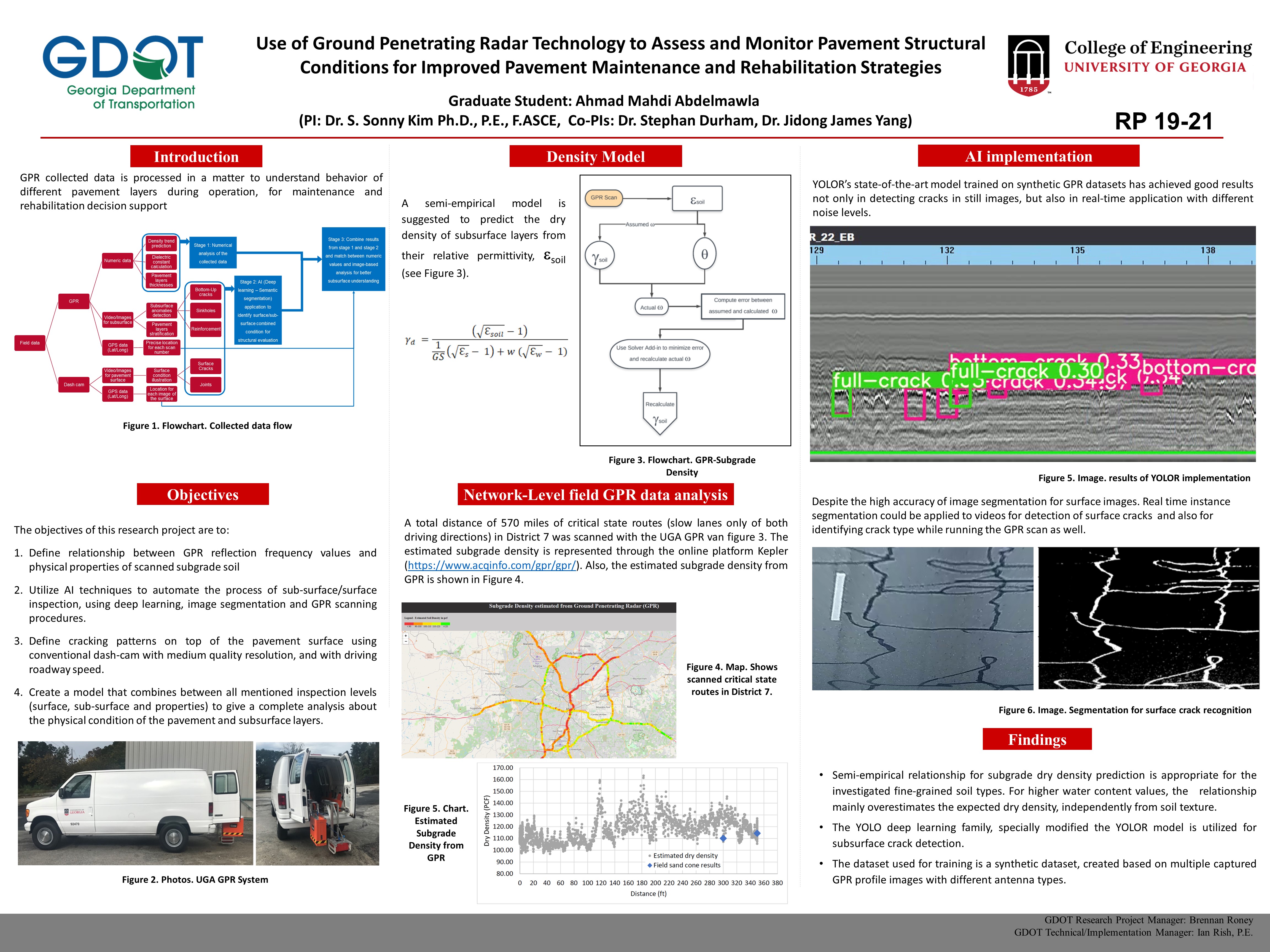
Subgrade density is one of the essential components for a structurally sound pavement system. In the field, subgrades soils are compacted to a desirable level to provide a robust platform for pavement layers. Insufficient field compaction is the most frequent construction-related issue resulting in lower subgrade density and potential structural failure. Electromagnetic (EM) density gauges have recently been introduced as an alternative to the nuclear density gauges. These nonnuclear devices use EM signals to measure in-situ density. Such EM density gauges eliminate the need for licenses, training, and specialized storage, as well as the risks associated with devices that use a radioactive source (Romero and Kuhnow, 2002). However, like the traditional methods, the nonnuclear density gauges do not provide continuous test results for the entire pavement area. Determining field subgrade condition in pavement requires a specified number of samples regardless of the density measurement method used. The sample-based assessment is only performed at limited spots and may not represent the entire surveyed road section. Further, a spot test may need traffic control during the test, which may cause traffic congestion. Therefore, a rapid and reliable test method that covers expansive surface areas becomes necessary to enhance the level of confidence in the evaluation. This study proposes a prediction model to estimate in-place subgrade dry density using ground penetrating radar (GPR) shown in Figure 1, which is fast, continuous, and reliable. Besides the subgrade density estimation, the GPR tests provide additional information about pavement structures, such as layers’ thicknesses and layers’ changes.
Please comment below with any statements or questions you may have. Also let GTI if you would be interested webinars or presentations on similar topics.
INVESTIGATION AND GUIDELINES FOR DRILLED SHAFT EXCAVATION INSPECTIONS
PI: Adam Kaplan
Co-PI(s): Jayhyun Kwon
Institution(s): Kennesaw State University
Abstract
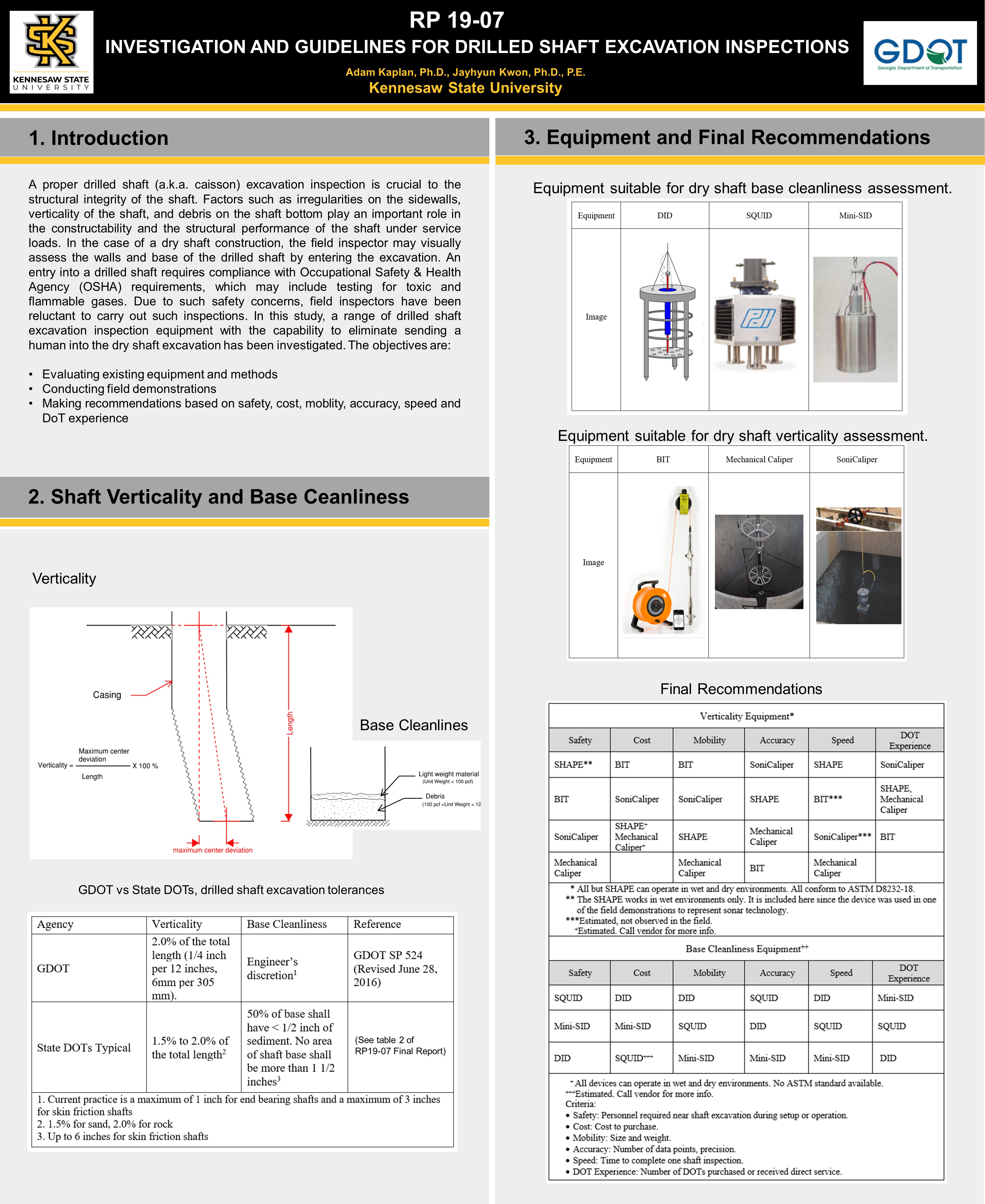
A proper drilled shaft (a.k.a. caisson) excavation inspection is crucial to the structural integrity of the shaft. Factors such as irregularities on the sidewalls, verticality of the shaft, and debris on the shaft bottom play an important role in the constructability and the structural performance of the shaft under service loads. In the case of a dry shaft construction, the field inspector may visually assess the walls and base of the drilled shaft by entering the excavation. An entry into a drilled shaft requires compliance with Occupational Safety & Health Agency (OSHA) requirements, which may include testing for toxic and flammable gases. Due to such safety concerns, field inspectors have been reluctant to carry out such inspections. In this study, a range of drilled shaft excavation inspection equipment with the capability to eliminate sending a human into the dry shaft excavation has been investigated. The objectives are: 1) Evaluating existing equipment and methods 2) Conducting field demonstrations 3) Making recommendations based on safety, cost, moblity, accuracy, speed and DoT experience
Please comment below with any statements or questions you may have. Also let GTI if you would be interested webinars or presentations on similar topics.
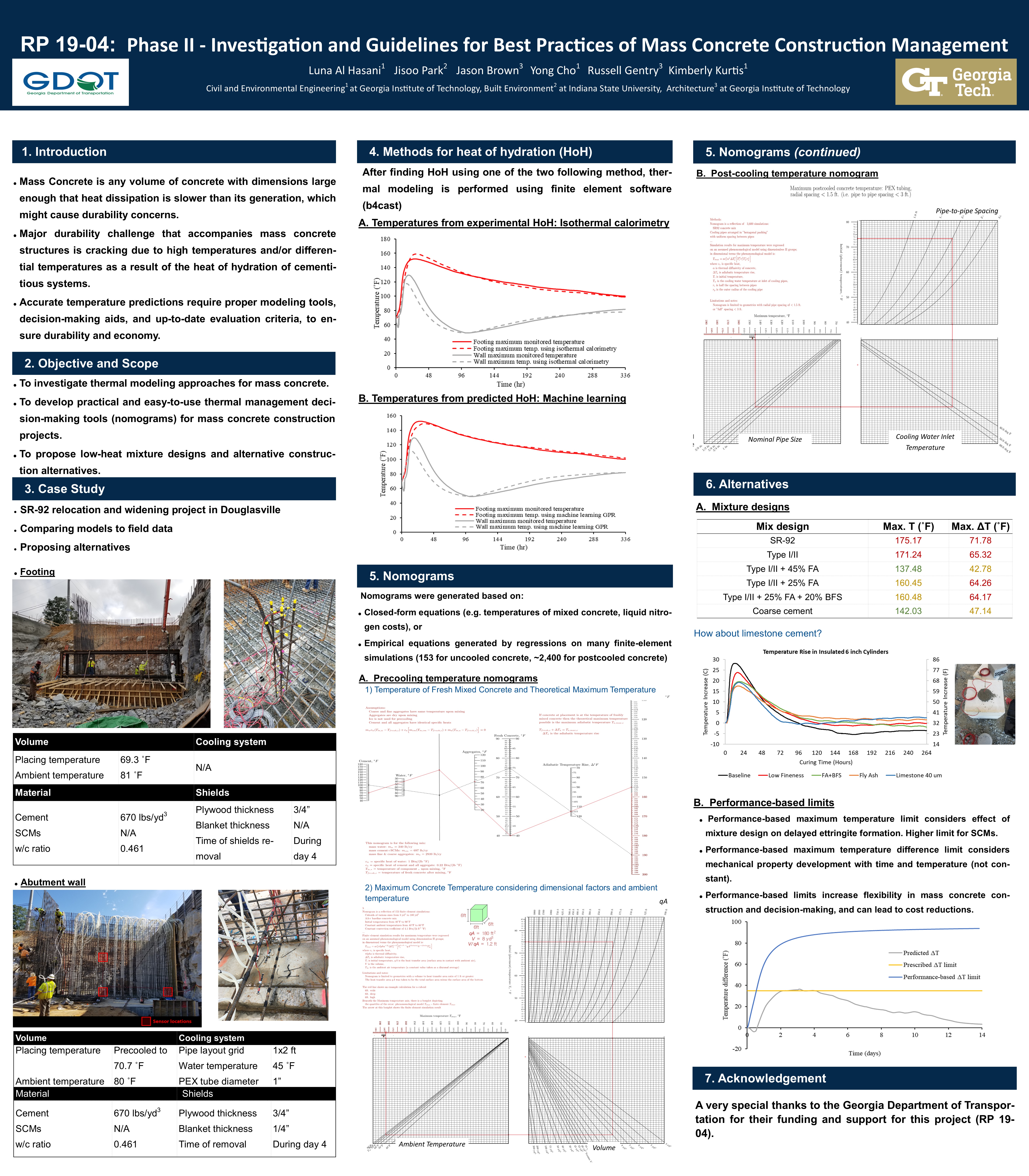
PHASE II – INVESTIGATION AND GUIDELINES FOR BEST PRACTICES OF MASS CONCRETE CONSTRUCTION MANAGEMENT
PI: Yong Cho
Co-PI(s): Kimberly Kurtis, and Russell Gentry
Institution(s): Georgia Institute of Technology
Abstract
The durability of mass concrete structures may be compromised due to stresses and cracking induced by temperature rise due to hydration of the concrete, and subsequent cooling. Delayed ettringite formation and thermal cracking may occur when maximum temperatures and maximum temperature differentials, respectively, are greater than the allowable thresholds. Construction practices in mass concrete scenarios, therefore, seek to limit maximum and differential temperatures below acceptable limits. This work investigates a mass concrete abutment wall that was constructed as part of relocating and widening a state road in Douglasville, Georgia beneath a railway line. Thermal control measures for the construction of the wall included both precooling of the concrete at the ready-mix plant using liquid nitrogen and post-cooling the abutment wall using internal cooling pipes. Both of these technologies increased the cost and complexity of construction. This research focuses on developing means to better characterize the heat of hydration of the cements and SCMs and temperature rise of concretes proposed for the project, and on proposing means to construct the abutment wall with less stringent and less costly thermal control measures. Alternative modeling approaches using isothermal calorimetry and machine learning, as well as nomogram decision-making tools have been proposed. Further analysis has been completed to investigate alternative design and construction options to satisfy maximum and differential temperature limits imposed by Georgia DOT guidelines. The variables considered are types and finenesses of cementitious materials, mix designs, concrete placement temperatures, and time of removal of insulation and formwork. It has been found that the accuracy of the thermal modeling can be improved with up-to-date techniques. The research concludes that both maximum and differential thermal limits could have been satisfied and post-cooling eliminated with the use of alternative materials and performance-based limits. The investigation shows that with proper heat of hydration modeling and decision-making tools, the cost and complexity of mass concrete construction can be significantly reduced.
Please comment below with any statements or questions you may have. Also let GTI if you would be interested webinars or presentations on similar topics.
Thursday June 15th, 2023 the Georgia Transportation Institute will hosted a 1-hour webinar that spotlighted two recently completed GDOT Research projects. Each project had maximum of a 15-minute presentation, with a short time afterward for questions.
You can join the event by using the Microsoft Teams link below:
Presenter: Susan E. Burns, Ph.D., P.E., F.ASCE, Dwight H. Evans Professor of Civil Engineering Director of the Georgia Transportation Institute Georgia Institute of Technology
Susan E. Burns, Ph.D., P.E., F.ASCE is the Dwight H. Evans Professor in the School of Civil and Environmental Engineering and Associate Chair for Administration and Finance at the Georgia Institute of Technology in Atlanta, Georgia, USA. Dr. Burns earned a B.C.E. Civil Engineering (‘90), M.S. Civil Engineering (‘96), M.S. Environmental Engineering (‘96), and Ph.D. in Civil Engineering (‘97), all from Georgia Tech. Dr. Burns’ research focuses on applications in geoenvironmental engineering including sustainability and beneficial use of waste materials; erosion, infiltration, and stormwater treatment on roadway rights-of-way; bio-mediated ground improvement; and fundamental chemical and engineering behavior of soils. Funding for her research group has come from a range of agencies, including the National Science Foundation, the US Department of Energy, the US Army Corps of Engineers, the US Department of Education, the Virginia Transportation Research Council, the Georgia Department of Transportation, Southern Company, and other industrial sources. Dr. Burns is a current member of the Committee on Corrosion of Buried Steel at New and In-Service Infrastructure (National Academies of Sciences, Engineering, and Medicine), and is a past member of the National Research Council’s (NRC) Standing Committee on Geological and Geotechnical Engineering, and a past member of the NRC’s Committee on Assessment of the Performance of Engineered Waste Containment Barriers. Her work on the beneficial use of waste materials was recognized with the Georgia Power Distinguished Professorship (2013 – 2018), and she frequently lectures on beneficial use of waste materials. Within the School of Civil and Environmental Engineering, Dr. Burns currently serves as Associate Chair for Administration and Finance, where she leads administration of the School’s budget, staff, facilities, and information technology. She previously served as the School’s Associate Chair for Undergraduate Programs, where she oversaw all aspects of the undergraduate degrees in Civil and Environmental Engineering, include ABET accreditation. She has had fellowships in the GT Provost’s Emerging Leader Program, the GT Inclusive Leaders Academy, and as a Diversity and Inclusion Fellow, where she is passionately committed to support of underrepresented minorities within engineering. Roughly half of her graduate students are members of underrepresented groups in engineering (women, BIPOC, Latinx). Dr. Burns is a fellow of the American Society of Civil Engineers, a recipient of the National Science Foundation CAREER award, the Arthur Casagrande Professional Development Award (ASCE), and she was named the 2020 Engineer of the Year by the Georgia Society of Professional Engineers (NSPE-GA). In 2021, Dr. Burns received the Class of 1940 W. Howard Ector Outstanding Teacher Award, which is Georgia Tech’s highest award for teaching. Most recently, Dr. Burns was selected as a Fellow in the Georgia Tech Faculty Executive Leadership Academy and was named one of the 100 most influential women in Georgia Engineering by the American Council of Engineering Companies of Georgia.
Title: GDOT RP-17-22 Optimizing Design of GDOT Post Construction Stormwater BMPs for Performance while Minimizing Right-of-Way Acquisition and Peak Flows
Abstract:
The objectives of this study were to evaluate the performance of stormwater best management practices (BMPs) used for stormwater quantity and quality control. Three field sites were tested to quantify hydraulic conductivity, infiltration, and solids removal efficiency. Removal efficiencies ranged from 12% to 35% of infiltrated runoff for VFS ranging from 15 ft. to 75 ft. long with slopes varying from 2% to 6%. For suspended solids removal, the VFS has the potential to remove between 21% and 43% when their design lengths range from 15 ft. to 75 ft long with slopes varying from 2% to 6%. It is recommended that partial credit be given for solids removal in filter strips that are shorter than the required 15 feet, and that filter strip designs incorporate the shallow grassed highway shoulder.
Presenter: Colin Usher Robotics Systems and Technology Branch Head Senior Research Scientist Georgia Institute of Technology
Colin Usher is a Senior Research Scientist and Branch Head of the Robotics Branch in the Intelligent Sustainable Technologies Division (ISTD) housed in the Aerospace, Transportation and Advanced Systems Laboratory (ATAS) at Georgia Tech Research Institute (GTRI). Mr. Usher joined GTRI in 2020 with a bachelor’s in computer science from the University of Georgia. One of his first projects he supported was the development of an adverse visibility warning system for the GDOT. He obtained a master’s degree in systems engineering from Southern Polytechnic State University in 2010. In the following years, he has performed as a technical lead and eventually a project manager on several efforts supporting clients ranging from industry, agriculture, transportation, and military. Most recently, his interest is in developing novel human/robot interfaces utilizing augmented and virtual reality systems.
Title: GDOT RP-17-15 Extended Field Testing of a Portable Pedestrian and Cyclist Detection System
Abstract:
The objective of this project was to enhance the capabilities of the pedestrian tracking system by adding support for detection and tracking of cyclists and vehicles, in addition to generating a set of tools to aid in analysis. Secondary tasks explored methods of enhancing the system capability for added value. The system analyzes the collected video data and automatically identifies and characterizes the number of pedestrians, vehicles, and cyclists and their behavior at midblock and intersection locations (specifically, their crossing locations and frequency). The system is designed to be portable to support data collection in multiple locations. Key conclusions from this study are: 1) A detection and tracking software system capable of creating and logging trajectories for pedestrians, vehicles, and cyclists was implemented and tested 2) Field testing of detection algorithms yielded accuracy between 90% and 95%, but count accuracy suffered at 53% 3) A set of powerful analysis tools was developed to allow in-depth analysis of results
Justin Hatch, P.E., Assistant State Traffic Engineer Georgia Department of Transportation
Ron Knezevich, EIT, State Safety Engineering Supervisor Georgia Department of Transportation
Rick Ayers, Public Sector Advocate, Center for Advanced Transportation Technology (CATT) Laboratory University of Maryland
Matt Glasser, National Transportation Systems Management and Operations (TSMO) Account Lead Arcadis
Data is critical to making informed decisions, evaluating the success of safety, operations, asset, and infrastructure investments, and developing effective and efficient strategies to ultimately improve the quality of life of Georgia citizens. Recognizing this need, GDOT has made extensive investments in data acquisition and access to a wide range of data and data products. These investments include state-wide mobility data for safety; vehicle speeds, flows, and volumes; traffic signal phasing and timing; traffic incident and congestion; and other data streams including connected vehicles probe data. GDOT has also invested in innovative platforms for the distribution, representation and analytics of these mobility data sources. Most importantly, GDOT has made these data available to the wider transportation community, including other state and local agencies, consultants, and the research community. This panel will present many of these new data sources and platforms, discuss use cases and access, and highlight future directions in mobility data investments.
The Georgia Department of Transportation has released the list of projects selected from the Fall 2022 RTAG submittals. Congratulations to the selected projects! Thanks to everyone who submitted a Research Needs Statement (RNS). The research community was highly engaged, with approximately 96 submitted needs statements. GDOT research staff is currently contacting the project PIs and setting up the next steps in the process.
The opening of the Fall 2023 RTAG RNS call will be announced later this year. Announcements will be distributed through the GTI mailing list and GTI website.
Please feel free to contact Supriya Kamatkar(skamatkar@dot.ga.gov) if you have any questions regarding the project selection process or Michael Hunter (michael.hunter@ce.gatech.edu) if you have any questions regarding GTI.
#
Project Title (Abbreviated)
Research Team
1
Ensuring Fair and Equitable Funding of Rural Transit in Georgia after the 2020 Census
Georgia Institute of Technology
2
Developing sight distance guidelines for U-turn maneuvers
Georgia Institute of Technology
3
Development of an ML-based Georgia Pavement Structural Condition Evaluation System
Georgia Institute of Technology
4
A Decision-Making Guide to Explore the Benefits of Design-Build-Maintain (DBM) and Design-Build-Operate-Maintain (DBOM) Alternative Delivery Systems to Assist GDOT in Anticipation of Emerging Technologies Deployed in GDOT’s Network
Georgia Institute of Technology
5
A Decision-Making Guide to Consider the Implementation of Progressive Public-Private Partnership (Progressive P3) for Delivering GDOT’s Major Projects
Georgia Institute of Technology
6
Investigate the impact of rumble strips on motorcyclists
Georgia Institute of Technology
7
Geotechnical asset management program in the State of Georgia – Phase I
Georgia Institute of Technology
8
Updating the GDOT’s Risk-based Programmed Contingencies Through Development of a Data-Driven Decision Tree Model
Georgia Institute of Technology & Kennesaw State University
9
Repair Guidelines for Impact-damaged Bridges
Georgia Institute of Technology & Kennesaw State University
10
Roadway Runoff Impacts to Trout Streams Studies for MS4 Permit
Georgia Southern University
11
Evaluation and Monitoring of an Appropriate and Context-Sensitive Warning System for Bridge Overhead Clearance Detection
Georgia Southern University
12
Develop Localized LRFD Procedure for Driven Piles with Dynamic Analysis for Georgia Bridge Foundations
Georgia Southern University
13
Fast and Efficient Welding Inspection of Structural Steel Using Adaptive Phased Array Ultrasonic NDT
Georgia Southern University
14
Effectiveness of Automated Speed Enforcement in School Zones and Guidance for Continuous Usage in Georgia
Kennesaw State University
15
Advanced 5.9GHz Interference Resiliency for Connected Vehicle Infrastructure
Kennesaw State University
16
Sustainable Application of Quarry By-Products in Georgia
Savannah State University & Kennesaw State University
17
Coastal Flood Roadway Vulnerability Assessment
University of Georgia
18
Develop an Off-System Bridge Managers Training Program to Increase Collaboration and Access to GDOT’s Resources Including LIBP and Promote Best Practices
University of Georgia
19
Investigation of heavier-than-expected vehicle weights observed in the vicinity of the Savannah port area and their impact on Georgia’s pavements and bridges
University of Georgia
20
Measurement of cement content and layer thickness variation of cement stabilized base and subgrade using ground penetrating radar
University of Georgia & Texas A&M University
21
Safety Effectiveness of Inside Shoulder Widths on Freeways in Georgia
Thursday May 11th, 2023 the Georgia Transportation Institute will hosted a 1-hour webinar that spotlighted two recently completed GDOT Research projects. Each project had maximum of a 15-minute presentation, with a short time afterward for questions.
You can join the event by using the Microsoft Teams link below:
Presenter: Michael Hunter, Ph.D., Professor Director of the Georgia Transportation Institute Georgia Institute of Technology
Dr. Hunter is a Professor in the School of Civil and Environmental Engineering at the Georgia Institute of Technology. Dr. Hunter joined the faculty of the Georgia Institute of Technology School of Civil and Environmental Engineering in the 2003. Dr. Hunter has been highly active in research, teaching, and service and has been principal investigator of sponsored research, for a variety of sponsors including local, state, federal, and industry. Dr. Hunter has led two significant transportation research centers, the Georgia Transportation Institute (GTI, 2012 to present) and the National Center for Transportation Systems Productivity and Management (NCTSPM, 2012 to 2017). Dr. Hunter is actively researching smart cities, connected vehicles and infrastructure, and disruptive technologies within the transportation systems context.
Title: RP 18-33 VISSIM Simulation Guidance
Abstract:
Where analytical tools such as the Highway Capacity Software™ (HCS), SYNCHRO®, etc. do not adequately represent traffic operations within a study area, or do not provide the necessary performance metric(s) required for the analysis, detailed simulation or similar approaches may be required. In such cases, the Georgia Department of Transportation (GDOT) typically employs PTV VISSIM™ as the preferred transportation modeling tool. This project has developed guidance material that enhances GDOT’s ability to review and utilize VISSIM™ models. To aid in the development of the necessary skills for VISSIM™ model review, a series of eight modules has been developed. The first four modules provide a basic introduction to arterial corridor and freeway model development, walking the reader step-by-step through the development of a small model containing unsignalized and signalized (fixed-time and actuated) control and a freeway segment and diamond interchange. The final four modules cover broader modeling issues, such as working with VISSIM™ results and direct output; underlying VISSIM™ model parameters and distributions; alternative model layouts and features; verification, calibration, and validation; and other issues critical to a thorough model review. These four modules culminate with reviewer checklists. After completion of all eight modules the GDOT reviewer will have been exposed to the knowledge and skills necessary to review and utilize a VISSIM™ model.
Presenter: Stephan Durham, Ph.D., P.E., Professor Assistant Dean for Student Success & Outreach The University of Georgia
Dr. Durham and his students discuss solutions to problems of urbanization, civil engineering innovations and engineering failures. They even build bridges out of spaghetti and glue.
Title: RP 20-16 Development of Training Modules to Increase Usage and Understanding of Agency-Wide Software Programs
Abstract:
The research objective is to develop a training program to assist Georgia Department of Transportation (GDOT) staff in learning and fully implementing agency-wide software programs. Specifically, this project will create online training modules for at least three programs: ProjectWise, Bluebeam, and CATS. The training program will be modelled after a successful on-going effort (RP17-18) to develop online learning modules for pavement design (AASHTOWare PavementME Software) for the Office of Materials and Testing (a sample video can be viewed at https://www.dropbox.com/s/i6zatlhz57nr1e1/MOD1A_PUB_M_Audio 2.mp4?dl=0). The online module development will utilize Adobe Captivate as the software for creating the eLearning content. Once developed, the modules are expected to optimize and balance work/training hours to allow employees to successfully use these software programs. Another objective conducted in parallel with the training modules development is to update the GDOT Construction Manual to include direction on the organization of content within and use of ProjectWise. This content is absent from the current Construction Manual.
Presenter: Rodger Purcell, Ph.D., Assistant Professor Georgia Southern University
Dr. Roger Purcell is affiliated to Civil Engineering and Construction Management, Georgia Southern University, where Dr. Roger Purcell is currently working as Assistant Professor. Dr. Purcell has authored and co-authored several national and international publications and also working as a reviewer for reputed professional journals. He has active association with different societies and academies around the world. He has Purcell made his mark in the scientific community with the contributions and widely recognition from honorable subject experts around the world and has received several awards for the contributions to the scientific community. His major research interest involves Civil Engineering and Construction Management.
Title: GDOT RP 18-10 Meeting the 21st Century Surveying- Geomatics Education Needs of GDOT and Georgia
Abstract:
This research project establishes ways to serve the surveying–geomatics (S-G) education needs of place-bound students, such as Georgia Department of Transportation (GDOT) personnel and others. It addresses the need for personnel with a 21st century education (knowledge and skills) in surveying–geomatics. Many factors, including lack of traditional student interest, lack of student preparedness, retirement-replacement issues, ever expanding technology and education materials, and post-recession demand, have forced the Georgia S–G community to recognize the need for an alternative approach to surveying–geomatics education. Thus, this study proposes a viable solution to the lack of S–G education availability and focuses on ways to foster Professional Land Surveyor (PLS) licensure, as well as improvements in salary and benefits for educated/licensed surveyors. The study also included the administration of a detailed survey based on matrix analysis of S-G knowledge/skill expectations, S-G position characterization, and S-G education subject area coverage. The results of the survey were analyzed to support the understanding of the breadth and depth of the 21st century S–G education among the Georgia S–G community