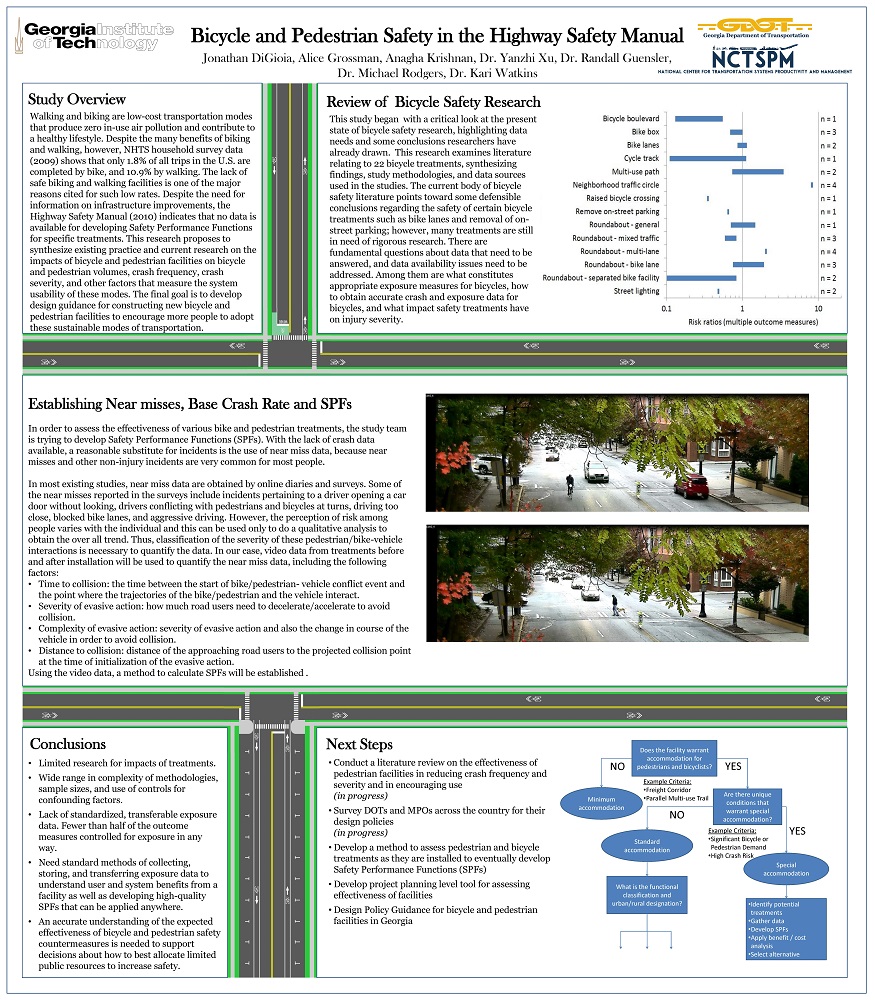
The objectives of this project are to: (1) develop a planning level tool that will aid the Georgia Department of Transportation (GDOT) in assessing the safety improvements associated with pedestrian and bicycle facilities in Georgia; and (2) provide design guidance for cost effective and safe pedestrian and bicycle facilities relevant to Georgia traffic and infrastructure.
PI:
Jonathan DiGioa, Alice Grossman, Anagha Krishnan, Yanzhi “Ann” Xu, Randall Guensler, Michael O. Rodgers, Kari E. Watkins
One of the main challenges that state departments of transportations (state DOTs) face in their design-build (DB) projects is to ensure that the design-build team upholds the highest standard of care in making complex engineering decisions involving multidisciplinary works. It is crucial to understand the underpinnings of engineering-related problems during both the design and construction phases and identify an effective approach to address these issues in the alternative delivery environment. This research aims to help the Georgia DOT (GDOT) Office of Innovative Delivery clearly define its expectations for the new position of project chief engineer (PCE). The overarching goal of this research project is to identify best practice guidance for defining GDOT?s expectations from the design-build team in proactive management of design-related issues. This study identifies gaps between GDOT?s expectations and the industry understanding of the PCE’s roles and responsibilities. Several emerging challenges related to the successful implementation of the new PCE position are discussed in the context of the dynamic design-build transportation market. The research team conducted content analysis and interviewed various professional groups, including state DOT officers, highway contractors, design consultants, owner’s representatives, legal experts, and insurance experts. To further discuss any issues related to insurability, the research team conducted a separate set of interviews with the insurance experts. The results show that, overall, interviewees agree that the PCE will add value for large and complex projects requiring multidisciplinary parties. The PCE requires a unique set of skills both in design and construction, and, therefore, finding an appropriate pool of candidates for the PCE position may be challenging for design-build teams. Several recommendations are made to enhance the description of the PCE role and responsibilities, in order to minimize any gaps in the understanding of the design-build industry professionals to fulfill this position. Not limited to the PCE position introduced by GDOT, the findings contribute to the DB and public-private partnership (P3) market to better understand the engineering decision-making process for the large and complex DB and P3 projects.
Please comment below with any statements or questions you may have. Also let GTI if you would be interested webinars or presentations on similar topics.
Georgia Department of Transportation (GDOT) must frequently consult with federal and state agencies to identify measures to avoid, minimize and mitigate impacts to imperiled aquatic organisms. Some of these measures, such as restrictions on in-water work during the reproductive season, impose substantial costs on GDOT projects. We developed an assessment of the sensitivities of the various imperiled taxa, and developed a system to provide flexibility for GDOT to employ the most effective measures for a given project, location and species. We also developed a template for a programmatic agreement that streamlined a system for evaluating GDOT projects and believe it will provide substantial cost savings for GDOT while improving outcomes for federally and state protected freshwater species.
Please comment below with any statements or questions you may have. Also let GTI if you would be interested webinars or presentations on similar topics.
The objectives of this study were to evaluate the performance of stormwater best management practices (BMPs) used for stormwater quantity and quality control. Three field sites were tested to quantify hydraulic conductivity, infiltration, and solids removal efficiency. Removal efficiencies ranged from 12% to 35% of infiltrated runoff for VFS ranging from 15 ft. to 75 ft. long with slopes varying from 2% to 6%. For suspended solids removal, the VFS has the potential to remove between 21% and 43% when their design lengths range from 15 ft. to 75 ft long with slopes varying from 2% to 6%. It is recommended that partial credit be given for solids removal in filter strips that are shorter than the required 15 feet, and that filter strip designs incorporate the shallow grassed highway shoulder.
Please comment below with any statements or questions you may have. Also let GTI if you would be interested webinars or presentations on similar topics.
IMPROVED DISASTER MANAGEMENT THROUGH AUTOMATED DAMAGE ASSESSMENT USING UNMANNED AERIAL VEHICLES (UAVS)
PI: Rami J. Haddad
Co-PI(s):
Institution(s): Georgia Southern University
Abstract
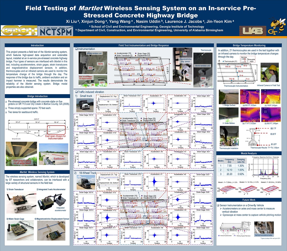
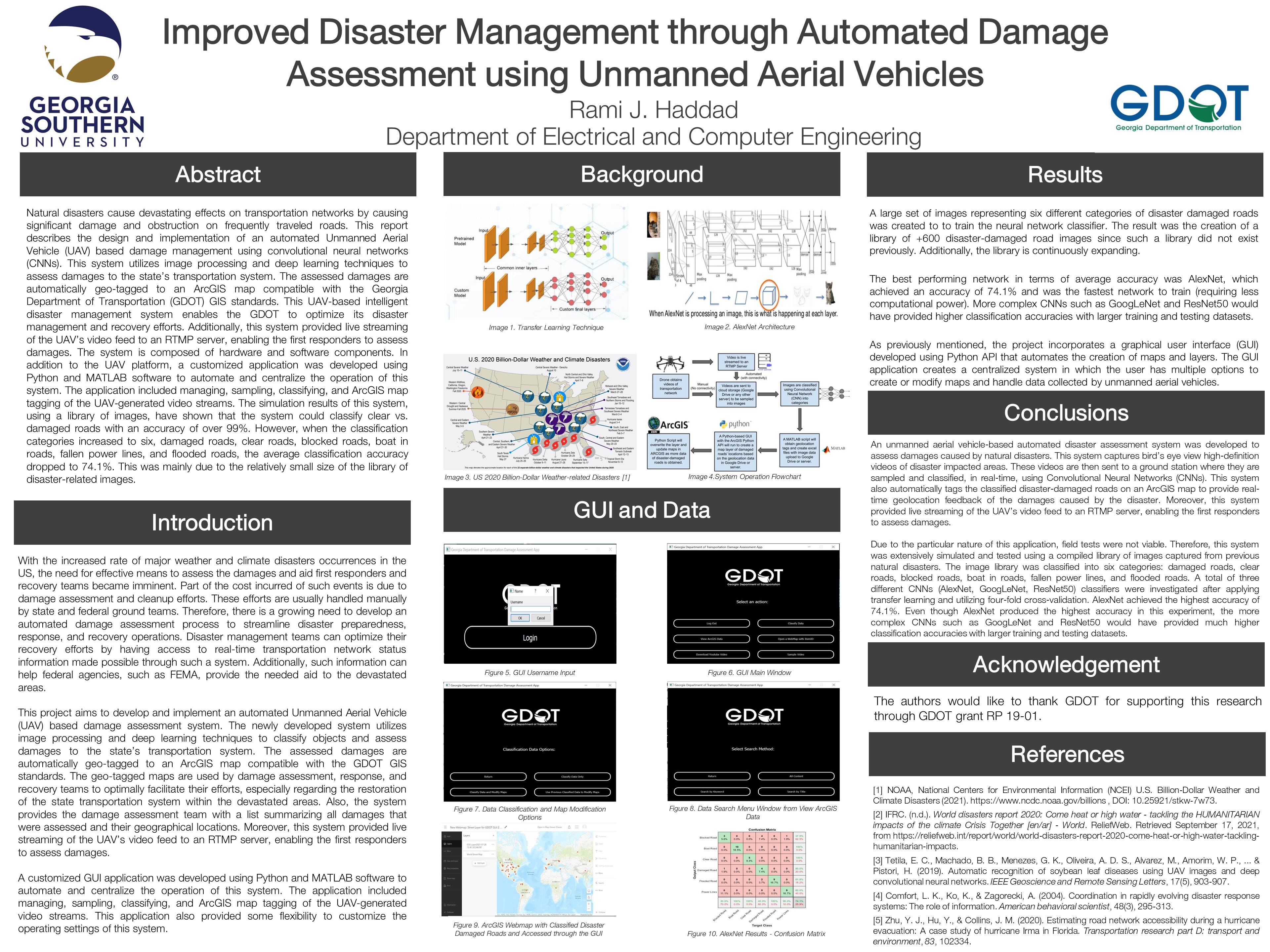
Natural disasters cause devastating effects on transportation networks by causing significant damage and obstruction on frequently traveled roads. This report describes the design and implementation of an automated Unmanned Aerial Vehicle (UAV) based damage management using convolutional neural networks (CNNs). This system utilizes image processing and deep learning techniques to assess damages to the state’s transportation system. The assessed damages are automatically geo-tagged to an ArcGIS map compatible with the Georgia Department of Transportation (GDOT) GIS standards. This UAV-based intelligent disaster management system enables the GDOT to optimize its disaster management and recovery efforts. Additionally, this system provided live streaming of the UAV’s video feed to an RTMP server, enabling the first responders to assess damages. The system is composed of hardware and software components. In addition to the UAV platform, a customized application was developed using Python and MATLAB software to automate and centralize the operation of this system. The application included managing, sampling, classifying, and ArcGIS map tagging of the UAV-generated video streams. The simulation results of this system, using a library of images, have shown that the system could classify clear vs. damaged roads with an accuracy of over 99%. However, when the classification categories increased to six, damaged roads, clear roads, blocked roads, boat in roads, fallen power lines, and flooded roads, the average classification accuracy dropped to 74.1%. This was mainly due to the relatively small size of the library of disaster-related images.
Please comment below with any statements or questions you may have. Also let GTI if you would be interested webinars or presentations on similar topics.
STRATEGIC PRIORITIZATION IN BRIDGE ASSET MAINTENANCE THROUGH DATA DRIVEN LONG-TERM ASSET VALUATION WITH ADDITIONAL EMPHASIS ON PROMOTING GDOT’S PARTNERSHIPS WITH COUNTIES
PI: Mi G. Chorzepa
Co-PI(s): Stephan Durham
Institution(s): University of Georgia
Abstract
The purpose of this project is to find ways to optimize bridge and transportation asset management and maintenance in the state of Georgia. This will be accomplished in a multitude of ways, but this project looks to bridge the gap in resources and knowledge between not only GDOT and local counties, but also among the counties themselves. To do this, this team will be developing an inspection guide, a resource guide, and an asset life-cycle analysis plan. Bridging the resource and knowledge gap between GDOT and local governments, as well as county to county, will go a long way towards fixing the divide between the conditions of state-owned transportation assets and local transportation assets.
Please comment below with any statements or questions you may have. Also let GTI if you would be interested webinars or presentations on similar topics.
In Georgia, when a hard/dense layer exists in the pile length or the vibration/noise during the driving causes secondary issues, a pilot hole is often adopted as a pile-driving assistance method to aid driving displacement piles through, especially if a competent hard rock layer exists in a reasonable depth. The use of a pilot hole reduces construction time and uncertainties related to driving through the problematic layers. However, the pilot hole is considered different from a pre-drilled hole in terms of construction method and design assumption. This process also complicates the prediction of long-term pile capacity with a predrilled hole. An objective of this study was to identify and document the current guidelines available and adopted by different states, and investigate the relationship between the load capacity of piles installed in rock and their design parameters with respect to the pilot hole, rock conditions, and installation method. Another objective was to identify a reliable design procedure that incorporates proper LRFD resistance factors, and a field verification method for quality assurance of rock. It is found that pile driving analyzer (PDA) can be applied to the piles with a pilot hole on rock and verify the structural capacity of the pile if not the geotechnical capacity due to the higher bearing capacity on rock. It also can check the internal stress to avoid the damage during striking. Thus, the study recommends the use of PDA tests and the AASHTO resistance factor for driven piles with dynamic testing, while collecting the strength properties of the rock mass. The driving refusal criterion can be used when the rock condition is evident. However, it is still recommended that the correlations between the refusal guidelines and rock properties are verified with PDA.
Please comment below with any statements or questions you may have. Also let GTI if you would be interested webinars or presentations on similar topics.
The overarching objective of this research is to develop Flash Tracking implementation guidelines that would complement the existing Design-Build Manual. These standardized implementation guidelines are captured in an appendix to the DesignBuild Manual. The research methodology comprised three phases. In the first phase, the research team studied and analyzed the effectiveness of flash track best practices implementation on three GDOT projects—namely, improvements to the I-16/I-95 interchange, the I-85 Widening, and SR 400 EL. In the second phase, the team reviewed and analyzed the GDOT DesignBuild Manual to identify its strengths, weaknesses, opportunities, and threats (i.e., a SWOT analysis) in terms of its treatment of flash track best practices. This involved cross-referencing the D-B manual against the 83 flash track best practices, to determine the presence or absence of each flash track best practice in the manual. In the third phase, an appendix to the D-B manual was developed to serve as an official source on implementing flash track best practices on D-B projects. Furthermore, modified RFQ and RFP templates were developed to incorporate flash track practices on projects and specific recommendations were made for the RFQ and RFP for the Houlihan Bridge P.I. No. 0013741/0013742 – SR 25 at Savannah & Middle River Bridges.
Please comment below with any statements or questions you may have. Also let GTI if you would be interested webinars or presentations on similar topics.