POSTER 20-09: DEVELOPMENT OF HIGHWAY MOWING OPERATIONS, MONITORING, AND VERIFICATION USING UAVS

PI: Javier Irizarry

Co-PI(s): Yong Kwon Cho 

Institution(s): Georgia Institute of Technology


Abstract

Vegetation control and roadside mowing on highway is a repetitive task conducted several times per year. Especially, verification of mowing work is labor-intensive, time-consuming and presents safety issues. This study focuses on a development of UAV-based automatic mowing inspection framework using computer vision and Artificial Intelligence. This work also presents a workflow analysis to optimize for the right-of-way mowing activities. The goal of this project is to develop an automated performance verification framework for highway grass condition monitoring tasks. The proposed method uses real highway image data captured by the UAV to process the grass classification and height estimation algorithms. The results from the proposed approaches are evaluated in terms of accuracy of detected grass regions and heights by comparing ground truth data. The outcome of this research will enhance and automate the roadway mowing inspection and monitoring process.


Please comment below with any statements or questions you may have. Also let GTI if you would be interested webinars or presentations on similar topics.

POSTER 20-03: ADEQUACY OF DSRC IN 5.9 GHZ BAND FOR GDOT’S CONNECTED VEHICLE INFRASTRUCTURE

ADEQUACY OF DSRC IN 5.9 GHZ BAND FOR GDOT’S CONNECTED VEHICLE INFRASTRUCTURE


PI: Seungmo Kim

Co-PI(s): 

Institution(s): Georgia Southern University


Abstract

Vehicle-to-everything (V2X) communications are expected to take a critical role in a variety of transportation safety applications in connected and autonomous vehicle environment. However, Dedicated Short-Range Communications (DSRC), one of the representative technologies implementing the V2X communications, is encountering challenges due to the re-allocation of the 5.9 GHz spectrum by the Federal Communications Commission (FCC). The state of Georgia is leading the nation in the deployment of connected vehicle infrastructure with thousands of infrastructure units connecting vehicles based on DSRC. This project aimed at measuring the impact of the spectrum re-allocation on the performance of the Georgia’s connected vehicle infrastructure. The project’s particular technical focuses were to (i) model the performance of a DSRC system and (ii) design a protocol to improve the DSRC performance, under the FCC’s reform of the 5.9 GHz band.


Please comment below with any statements or questions you may have. Also let GTI if you would be interested webinars or presentations on similar topics.

POSTER 20-22 ENHANCING AND GENERATING GDOT’S MUTCD CURVE SIGN PLACEMENT DESIGN WITH CURVE FINDER AND CURVE SIGN DETERMINATION

ENHANCING AND GENERATING GDOT’S MUTCD CURVE SIGN PLACEMENT DESIGN WITH CURVE FINDER AND CURVE SIGN DETERMINATION


PI: James (Yichang) Tsai

Co-PI(s): 

Institution(s): Georgia Institute of Technology


Abstract

Though curves represent only 5% of highway miles, they account for 25% of fatal roadway crashes. Thus, the MUTCD requires various warning signs to ensure safety on curves. GDOT?s current MUTCD-compliant curve sign design practice is labor-intensive and time-consuming, especially the determination of detailed curve geometry and the validation of the sign placement which must be done for only one curve at a time. Therefore, there is an urgent need to enhance this practice. The objectives of this project are to enhance the GDOT curve sign design practice by automatically batch processing multiple curves at once to extract sensor data including curve geometry, BBI, speed limit, and GPS location. This information will then be used compute the necessary advisory speed for the curve, generate MUTCD-compliant curve signs in a tabular format, and visualize these signs for streamlined implementation by GDOT. This processing will be done using an application previously developed by Georgia Tech for high friction surface treatment location. This project can save time, money, and effort for GDOT as well as increase confidence in the accuracy of the curve sign placement design on a network level.


Please comment below with any statements or questions you may have. Also let GTI if you would be interested webinars or presentations on similar topics.

POSTER 20-28: DYNAMIC DIFFUSION GRAPH CONVOLUTIONAL NETWORKS FOR NETWORK TRAFFIC ESTIMATION

DYNAMIC DIFFUSION GRAPH CONVOLUTIONAL NETWORKS FOR NETWORK TRAFFIC ESTIMATION


PI: Jidong J Yang

Co-PI(s): Sonny Kim, Stephan Durham, and Mi Geum Chorzepa

Institution(s): University of Georgia


Abstract

Network traffic estimation and forecasting is fundamental to transportation systems analysis and decision making in planning, design, and operation of such systems. The rapid development of intelligent transportation systems (ITS) and emerging avant-garde monitoring technologies have made traffic data collection more convenient and efficient in support of decision making at various levels. In practice, permanently located continuous count stations, complemented with portable traffic counters, are typically used for traffic data collection. However, due to budget and personnel constraints, only a limited number of segments in the road network are equipped with sensors. In other words, the network traffic flows are only partially observable, which may lead to unexpected consequences due to uncertainty and associated biases. In this study, we introduces a novel graph-based approach for estimating network-wide traffic volumes from limited sensor locations.


Please comment below with any statements or questions you may have. Also let GTI if you would be interested webinars or presentations on similar topics.

POSTER 20-02: Assessing the Applicability of Open-format Video in Pavement Condition Data Quality Control Procedures

ASSESSING THE APPLICABILITY OF OPEN-FORMAT VIDEO IN PAVEMENT CONDITION DATA QUALITY CONTROL PROCEDURES


PI: James (Yichang) Tsai

Co-PI(s): 

Institution(s): Georgia Institute of Technology


Abstract

Data-driven pavement quality management, including QA and QC procedures, is mandated by HPMS and required for the GDOT. Unfortunately, the previous lack of an open format for pavement condition data made this difficult. The newly-developed standard specification of ?2-Dimensional and 3-Dimensional (2D/3D) Pavement Image Data File Format? is an open-format 2D/3D pavement data standard that could potentially be used by GDOT to independently validate pavement condition data quality. Thus, the objectives of this project are 1) to assess the feasibility of using this open-format standard in support of GDOT?s independent validation of the quality of the pavement condition data, and 2) to recommend the work for implementing this open-format data standard. The test outcomes from the pixel-by-pixel range data comparison show the conversion steps are lossless for different pavement surface types and different pavement conditions, and so it is feasible to convert 3D data into the open-format standard data in support of GDOT?s pavement data quality control.


Please comment below with any statements or questions you may have. Also let GTI if you would be interested webinars or presentations on similar topics.

POSTER 20-09: DEVELOPMENT OF HIGHWAY MOWING OPERATIONS, MONITORING, AND VERIFICATION USING UAVS

DEVELOPMENT OF HIGHWAY MOWING OPERATIONS, MONITORING, AND VERIFICATION USING UAVS


PI: Javier Irizarry

Co-PI(s): Yong Kwon Cho

Institution(s): Georgia Institute of Technology


Abstract

Vegetation control and roadside mowing on highway is a repetitive task conducted several times per year. Especially, verification of mowing work is labor-intensive, time-consuming and presents safety issues. This study focuses on a development of UAV-based automatic mowing inspection framework using computer vision and Artificial Intelligence. This work also presents a workflow analysis to optimize for the right-of-way mowing activities. The goal of this project is to develop an automated performance verification framework for highway grass condition monitoring tasks. The proposed method uses real highway image data captured by the UAV to process the grass classification and height estimation algorithms. The results from the proposed approaches are evaluated in terms of accuracy of detected grass regions and heights by comparing ground truth data. The outcome of this research will enhance and automate the roadway mowing inspection and monitoring process.


Please comment below with any statements or questions you may have. Also let GTI if you would be interested webinars or presentations on similar topics.

POSTER 20-10: DEVELOPMENT OF DRONE-ASSISTED PAVEMENT PROFILE MAPPING: NEAR-SURFACE VOID DETECTION APPLICATION.

[20-10] DEVELOPMENT OF DRONE-ASSISTED PAVEMENT PROFILE MAPPING: NEAR-SURFACE VOID DETECTION APPLICATION.


PI: Javier Irizarry

Co-PI(s): Tarek Rakha

Institution(s): Georgia Institute of Technology


Abstract

Near-surface voids can develop into potholes and spalling causing potential driving hazards. A UAS with dual camera sensors can efficiently collect infrared (IR) and visual (RGB) images. This research studied the application of Computer Vision and Deep Learning to analyze UAV-collected multi-spectrum images to detect areas with voids beneath pavement surfaces.


Please comment below with any statements or questions you may have. Also let GTI if you would be interested webinars or presentations on similar topics.

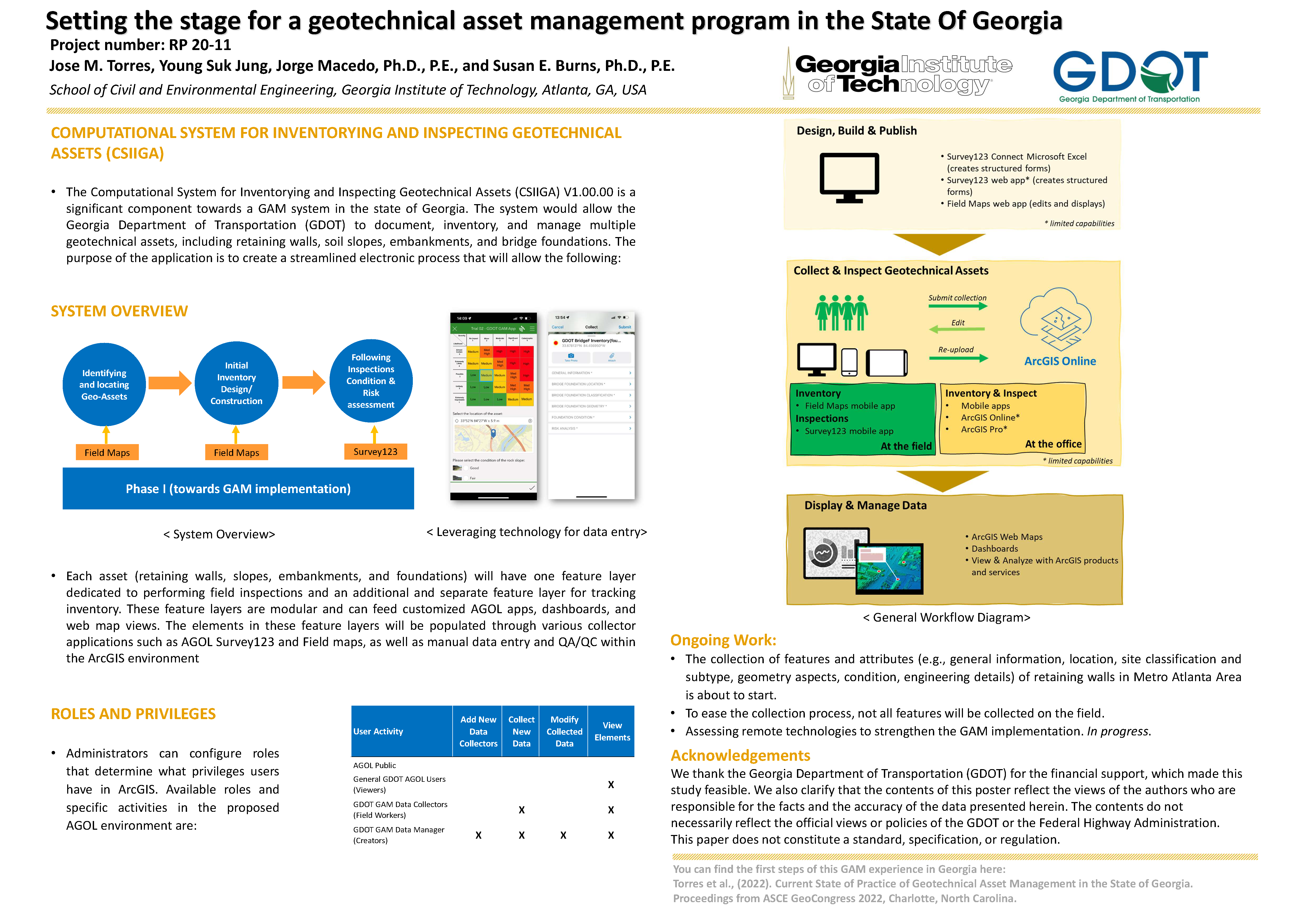
POSTER 20-11: TOWARDS THE IMPLEMENTATION OF A GEOTECHNICAL ASSET MANAGEMENT PROGRAM IN THE STATE OF GEORGIA.

TOWARDS THE IMPLEMENTATION OF A GEOTECHNICAL ASSET MANAGEMENT PROGRAM IN THE STATE OF GEORGIA.


PI: Jorge Macedo

Co-PI(s): Susan Burns

Institution(s): Georgia Institute of Technology


Abstract

This poster portrays the Computational System for Inventorying and Inspecting Geotechnical Assets (CSIIGA) as a significant component towards a GAM program in the state of Georgia. The system would allow the Georgia Department of Transportation (GDOT) to document, inventory, and manage multiple geotechnical assets, including retaining walls, soil slopes, embankments, and bridge foundations.


Please comment below with any statements or questions you may have. Also let GTI if you would be interested webinars or presentations on similar topics.

POSTER 20-12: INCORPORATING RESILIENCE CAPABILITIES INTO LONG-RANGE TRANSPORTATION PLANS: FLEXIBILITY AND AGILITY

INCORPORATING RESILIENCE CAPABILITIES INTO LONG-RANGE TRANSPORTATION PLANS: FLEXIBILITY AND AGILITY


PI: Adjo Amekudzi-Kennedy

Co-PI(s): 

Institution(s): Georgia Institute of Technology


Abstract

Transportation systems are key to supporting the safety and mobility of urban and rural populations and are part of overall infrastructure systems that also include water facilities, electricity and power plants, communication networks, and others. These vital systems are affected by changes to the environment, political systems, and technological landscapes in which they operate. Recently, COVID-19 showed that there are unknown threats that can disrupt infrastructure planning, funding, design, construction, usage, and many other critical components of transportation systems. Simultaneously, transportation planners are faced with changing conditions due to increasing frequency of extreme weather events, varying demands from increasingly diverse populations, and shifting funding needs and sources. The dynamic conditions and emerging complex challenges will impact the way that agencies write and design their long-range transportation plans (LRTPs). Flexibility and agility are qualities that have emerged in the literature as ways to increase resilience in transportation planning, but there are currently no formalized pathways for incorporating flexibility and agility into long-range transportation planning. This research creates a framework for organizations to adopt these qualities into their planning processes. This research develops a tool to easily incorporate these qualities into LRTP development and evaluates GDOT?s Statewide Strategic Transportation Plan from 2021 for gaps and opportunities to increase flexibility and agility. Based on the evaluation, specific recommendations are provided to GDOT to support the development of these capabilities.


Please comment below with any statements or questions you may have. Also let GTI if you would be interested webinars or presentations on similar topics.

POSTER 20-12A: INCORPORATING ACCESSIBILITY INTO VULNERABILITY ASSESSMENTS FOR ENHANCED EQUITY AND RESILIENCE

INCORPORATING ACCESSIBILITY INTO VULNERABILITY ASSESSMENTS FOR ENHANCED EQUITY AND RESILIENCE


PI: Adjo Amekudzi-Kennedy

Co-PI(s): 

Institution(s): Georgia Institute of Technology


Abstract

Transportation systems are key to serving the basic needs of society. These critical systems are impacted by increasing frequency of disasters, aging infrastructure, and changing social demands. Vulnerability assessments examining exposure, sensitivity, and adaptive capacity are factors of transportation resilience that reflect the ability of infrastructure to withstand, adapt to, and respond to disruptions. At the same time, there are basic standards for transportation that are often captured by accessibility measures. These standards are a contributing factor to enhancing community resilience, but they are often considered separately from transportation resilience analysis. Ensuring that accessibility standards are met before implementing other projects can reduce the vulnerability of transportation users and the system at large, thus enhancing long-term system resilience. Applying the principles of negotiated resilience may enable agencies to address more effectively emerging demands and competing priorities for all stakeholders. This research first provides a clear prioritization pathway that accounts for vulnerability and accessibility indicators. From there, we provide an analysis exploring relevant indicators for each of these concepts for the state of Georgia. A stakeholder outreach event and workshop focused on transportation practitioners and emergency managers in Georgia enabled us to validate our analysis and gain more insight into the current state of practice concerning vulnerability assessment and adaptation. This workshop was designed to incorporate and apply emerging theory regarding negotiated resilience. This research develops and demonstrates a framework for conducting future vulnerability assessments that reflect the basic transportation needs of communities in addition to the vulnerability of physical infrastructure.


Please comment below with any statements or questions you may have. Also let GTI if you would be interested webinars or presentations on similar topics.