POSTER 20-24: AERMOD, RLINE, AND RLINEXT CASE STUDY ANALYSES IN ATLANTA, GEORGIA

AERMOD, RLINE, AND RLINEXT CASE STUDY ANALYSES IN ATLANTA, GEORGIA


PI: Randall Guensler

Co-PI(s): Hongyu Lu, William Reichard, Ziyi Dai, Tian Xia, Angshuman Guin, Ph.D., and Michael O. Rodgers, Ph.D.

Institution(s): Georgia Institute of Technology


Abstract

This research assessed the impact of USEPA?s AERMOD dispersion model (version of 19191) source types on predicted pollutant concentrations via a case study for the I-75/I-575 Northwest Corridor (NWC) in Atlanta, GA. Using MOVES-Matrix for MOVES 2014b, carbon monoxide (CO) emissions rates for every hour of a one-year study period were generated using traffic volumes and speed from Atlanta Regional Commission’s Activity-Based Model (ABM) 2020 and AERMET meteorological profiles provided by the state environmental agency (EPD). To develop concentration profiles to assess prediction differences across source types, consistent input datasets for hourly emissions by ABM link, hourly AERMET data, and gridded receptor placement (standard 20-meter grids and variable grids after link-screening) were run with the AERMOD source types: AREAPOLY (manually created and automatically generated), LINE, VOLUME, RLINE, and RLINEXT (with and without noise barriers). The team processed more than one trillion source-receptor pairs the study area using the cyberinfrastructure resources provided by the Partnership for an Advanced Computing Environment (PACE) at Georgia Tech. The results indicate that predictions from AREAPOLY and LINE are essentially identical. Predictions from RLINE and RLINEXT are almost the same, but these predictions are higher in most cases than any other source type. The VOLUME source type always yields the lowest concentrations and is less sensitive to wind directions and speed, due to the embedded wind meander dispersion parameters implemented only for VOLUME sources. Machine learning results indicate that wind speed, receptor ID (which accounts for adjacent roads and their and their mass flux emission rates in grams/meter2/second), and wind direction influence the results much more than source type selection. Introducing noise barriers to RLINEXT lowered concentration as expected, but modeling barrier effects was challenging due to the restrictive assumptions in AERMOD. Sensitivity analysis for RLINEXT suggests that barrier height, distance to the roadway, wind speed, and wind direction all affect morel predictions. Modelers need to exercise care in matching barriers to roadway link segments (i.e., barrier edge effects were observed).


Please comment below with any statements or questions you may have. Also let GTI if you would be interested webinars or presentations on similar topics.

POSTER 20-25: VIRTUAL PUBLIC INVOLVEMENT (VPI): GUIDANCE FOR ENCOURAGING PUBLIC PARTICIPATION AND SOLICITING FEEDBACK DURING THE TRANSPORTATION PLANNING PROCESS

VIRTUAL PUBLIC INVOLVEMENT (VPI): GUIDANCE FOR ENCOURAGING PUBLIC PARTICIPATION AND SOLICITING FEEDBACK DURING THE TRANSPORTATION PLANNING PROCESS


PI: Baabak Ashuri

Co-PI(s): Gordon Kingsley

Institution(s): Georgia Institute of Technology


Abstract

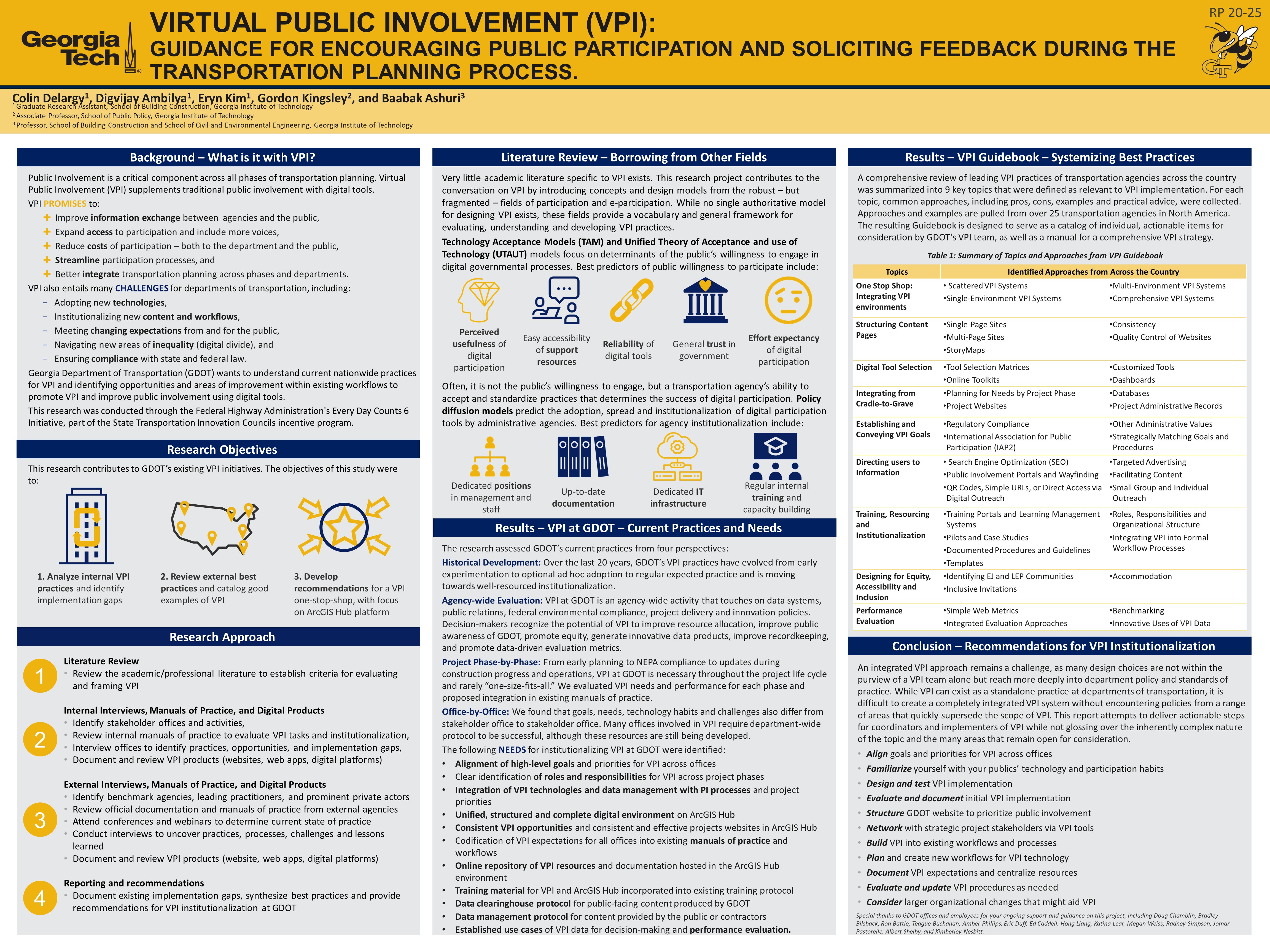
In transportation planning and decision-making processes, public involvement (PI) is critical as the daily users of transportation share useful insights, opinions, and observations on the performance and needs of the transportation systems. Virtual Public Involvement (VPI) is the use of digital technology to engage individuals in project planning and decision making. It is intended to supplement face-to-face information sharing with virtual tools, and thus broaden existing approaches to public involvement to include more voices. The overarching objectives of this research were to gather and evaluate information on existing approaches to VPI and to provide recommendations for the development of a single-platform VPI environment on ArcGIS Hub that encourages widespread participation, facilitates two-way communication, and integrates VPI requirements into an inter- office, cradle-to-grave VPI process. The literature review provides examples of public participation design and key factors that contribute to the successful acceptance of VPI by the public. A review of GDOT practice identified the tasks, challenges, and goals for VPI by project phase and department and identified gaps in existing practice. A review of the community of practice was compiled to provide approaches to key tasks necessary for the design, implementation, and institutionalization of VPI across the country. Finally, 11 recommendations for institutionalizing VPI at GDOT were provided.


Please comment below with any statements or questions you may have. Also let GTI if you would be interested webinars or presentations on similar topics.

POSTER 20-19: DURABLE NEXT-GENERATION CONCRETE SPECIFICATIONS

DURABLE NEXT-GENERATION CONCRETE SPECIFICATIONS


PI: Kimberly Kurtis

Co-PI(s): Samuel Paredes, and Devon Golden

Institution(s): Georgia Institute of Technology


Abstract

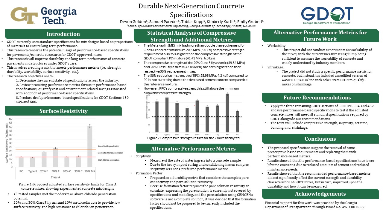
This poster goes over suggested performance metrics for GDOT in order to bring durability to the forefront of priorities alongside strength. The purpose of recommending the switch from prescriptive-based to performance-based specifications would be to decrease maintenance costs over time, as well as grant longer life spans. This poster also touches on how the suggested performance metrics and alterations to current limitations does not significantly lower strength characteristics or current durability metrics.


Please comment below with any statements or questions you may have. Also let GTI if you would be interested webinars or presentations on similar topics.
POSTER 20-18: EXPERIMENTAL TEST MATRIX OVERVIEW OF COATING PERFORMANCE ON ALKALI-SILICA REACTION AFFECTED CONCRETE

EXPERIMENTAL TEST MATRIX OVERVIEW OF COATING PERFORMANCE ON ALKALI-SILICA REACTION AFFECTED CONCRETE


PI: Kimberly Kurtis

Co-PI(s): Lauren Stewart

Institution(s): Georgia Institute of Technology


Abstract

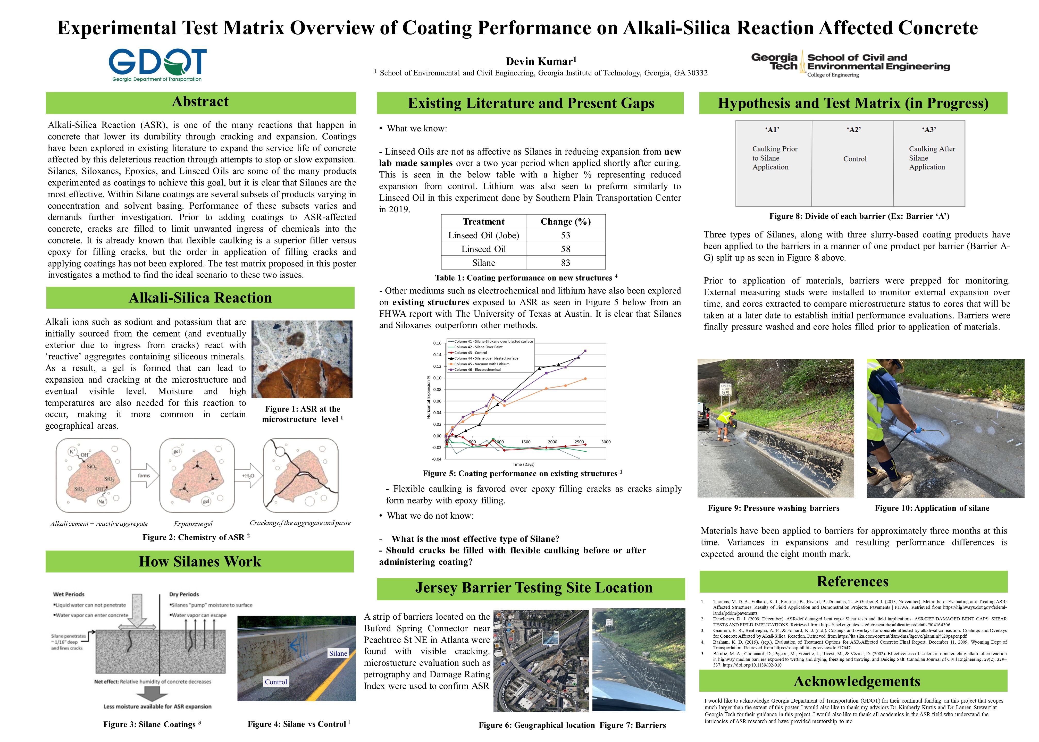
Alkali-Silica Reaction (ASR), is one of the many reactions that happen in concrete that lower its durability through cracking and expansion. Coatings have been explored in existing literature to expand the service life of concrete affected by this deleterious reaction through attempts to stop or slow expansion. Silanes, Siloxanes, Epoxies, and Linseed Oils are some of the many products experimented as coatings to achieve this goal, but it is clear that Silanes are the most effective. Within Silane coatings are several subsets of products varying in concentration and solvent basing. Performance of these subsets varies and demands further investigation. Prior to adding coatings to ASR-affected concrete, cracks are filled to limit unwanted ingress of chemicals into the concrete. It is already known that flexible caulking is a superior filler versus epoxy for filling cracks, but the order in application of filling cracks and applying coatings has not been explored. The test matrix proposed in this poster investigates a method to find the ideal scenario to these two issues.


Please comment below with any statements or questions you may have. Also let GTI if you would be interested webinars or presentations on similar topics.

POSTER 20-16: DEVELOPMENT OF TRAINING MODULES TO INCREASE USAGE AND UNDERSTANDING OF AGENCY-WIDE SOFTWARE PROGRAMS

DEVELOPMENT OF TRAINING MODULES TO INCREASE USAGE AND UNDERSTANDING OF AGENCY-WIDE SOFTWARE PROGRAMS


PI: Stephan A. Durham

Co-PI(s): Mi Geum Chorzepa, Sonny Kim, and Baabak Ashuri

Institution(s): The University of Georgia


Abstract

Much of Georgia Department of Transportation?s (GDOT) current training practices are provided by the Human Resources Training and Development Office of GDOT through its Employee Learning Management System (ELMS). However, there is currently no on-demand training for a large portion of GDOT?s software needs including ProjectWise, Bluebeam, and CATS. RP 17-13 Development of Implementation Plan for GDOT E-Construction Program investigated 22 software types used across 15 offices and determined the need for GDOT specific training materials for the 3 software types listed above.


Please comment below with any statements or questions you may have. Also let GTI if you would be interested webinars or presentations on similar topics.
POSTER 20-15: RECOMMENDATIONS FOR NDT OF CONCRETE COMPONENTS FOR PERFORMANCE-BASED SPECIFICATIONS

RECOMMENDATIONS FOR NDT OF CONCRETE COMPONENTS FOR PERFORMANCE-BASED SPECIFICATIONS


PI: Laurence Jacobs

Co-PI(s): Kim Kurtis, Ryan Sherman, Jin-Yeon Kim and Jianmin Qu

Institution(s): Georgia Institute of Technology


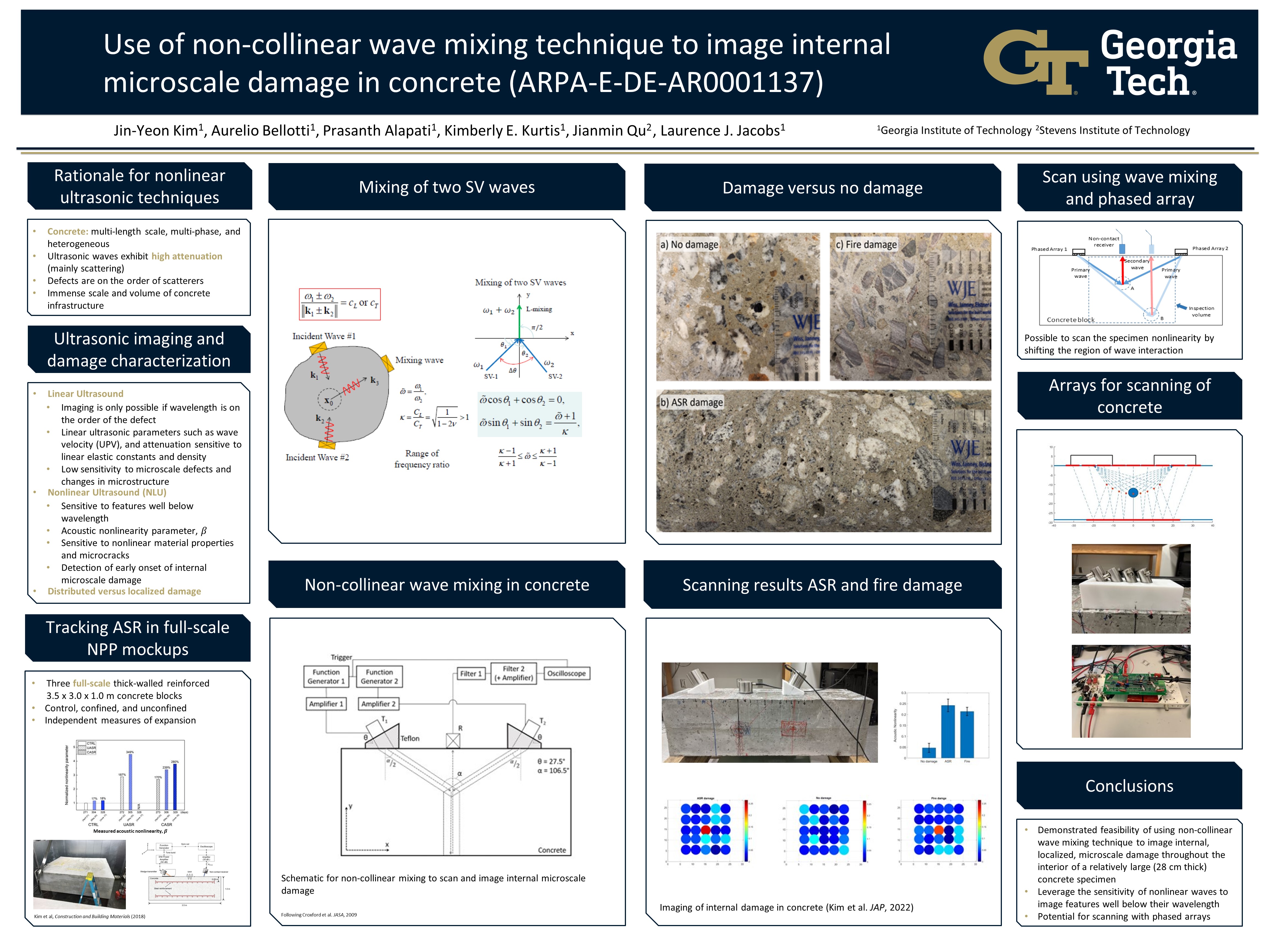
Abstract

This poster demonstrates the feasibility of using a non-collinear wave mixing technique to image internal microscale damage throughout the interior volume of a relatively large (28 cm thick) concrete component. Unlike metals, concrete is rather heterogeneous with inherent microstructural features ranging in length from nanometers to millimeters or even centimeters. Many damage features that may significantly reduce the concrete material’s integrity are also within this range of length scales. This multiphase, heterogeneous, and multiscale nature of concrete makes the development of linear ultrasound based NDE and monitoring techniques for concrete technically challenging. Successful imaging using ultrasound requires that the ultrasonic wavelength be on the order of a few millimeters, yet the inherent length scale of this heterogeneous material with its fine and coarse aggregates is on this same millimeter length scale and larger. By exploiting the underlying mechanics of nonlinear wave mixing, this research shows it is possible to mix two incident waves with frequencies low enough to propagate without being scattered by the inherently heterogenous, concrete microstructure, while still being sensitive to damage features with length scales well below these incident wavelengths. Scanning and imaging is accomplished by manually adjusting the locations of the two incident waves, while knowledge of the wave speeds in concrete plus synchronization identifies the location of the mixing zone – the specific volume of concrete being imaged. The viability of the proposed technique is demonstrated by examining a concrete prism specimen with known, embedded internal microscale damage.


Please comment below with any statements or questions you may have. Also let GTI if you would be interested webinars or presentations on similar topics.

POSTER 20-14: GUIDELINES FOR INCORPORATION OF CEMENT STABILIZED RECLAIMED BASE (CSRB) IN PAVEMENT DESIGN

GUIDELINES FOR INCORPORATION OF CEMENT STABILIZED RECLAIMED BASE (CSRB) IN PAVEMENT DESIGN


PI: Jayhyun Kwon

Co-PI(s): Youngguk Seo

Institution(s): Kennesaw State University


Abstract

GDOT is in the process of implementing an updated Mechanistic-Empirical Pavement Design Guide (MEPDG). To support this implementation, a research study was conducted to calibrate the national performance models for local conditions. However, reliable calibration coefficients could not be derived for semi-rigid pavements due to the lack of sufficient performance data. GDOT will therefore continue to utilize the current pavement design procedure (AASHTO 72/93) until appropriate MEPDG local calibration coefficients have been identified. This research project was undertaken to improve the reliability of the current GDOT pavement design procedure for CSRB and to provide recommendations regarding the steps required to verify and calibrate CSRB for use in MEPDG. A preliminary laboratory study of typical CSRB mix and field cores was conducted to characterize the CSRB materials and evaluate the accuracy of the relationship between elastic modulus and unconfined compressive strength, after which performance data was collected for samples from 4 different sites in Georgia. The FWD deflection data and UCS values of the field cores were then used to calculate the structural layer coefficient of the CSRB layer and a sensitivity analysis was performed to identify the input variables with the greatest influence on the performance predicted by the PMED. Two different pavement types were used to model the FDR pavement: flexible pavement and semi-rigid pavement. Finally, a data collection plan was developed to guide the collection of the data needed for local calibrations of the MEPDG for roads in Georgia.


Please comment below with any statements or questions you may have. Also let GTI if you would be interested webinars or presentations on similar topics.
POSTER 20-01: REAL-TIME NETWORK ASSESSMENT AND UPDATING USING VEHICLE-LOCATING DATA

REAL-TIME NETWORK ASSESSMENT AND UPDATING USING VEHICLE-LOCATING DATA


PI: Iris Tien

Co-PI(s): Zachary Roberts

Institution(s): Georgia Institute of Technology


Abstract

Road infrastructure makes up a crucial component of Georgia’s asset network. Throughout the state, connections link different areas to each other, providing access to employment, social, and health services, thereby stimulating economic development. Halting these services are the presence of road blockages, including vehicular accidents, debris, flooding, which limit/prohibit travel along reported routes. Real-time traffic information needs to be collected and processed to ensure timely maintenance and hazard minimization. As most past studies have focused on stationary sources for real-time network analysis1 (e.g., loop detectors and traffic cameras), this study will utilize the wider-reaching and lower operational costing mobile sources of GDOT employee vehicles. Our network analysis will draw from three sources of data provided by GDOT (seen below in Figures 1-3, respectively): Georgia Network Database, WebEOC Executive Report, and the Verizon Network Fleet Database. The Georgia Network Database consists of a series of interconnected polylines representing the midpoint of Georgia roads. The WebEOC Executive Report is a large .csv file with the state route location, incident description, and the number of lanes passable. With processing, the data is converted into a usable ArcGIS Shapefile (.shp). The GDOT Verizon Network Fleet Geodatabase is a converted .csv of GDOT vehicle tracking information, including Vehicle ID, location, time, and ignition status of the vehicle (On/Off). Vehicles will be tracked with the same IDs in increments of 2 minutes to create vehicle route segments for further analysis.

Project Video


Please comment below with any statements or questions you may have. Also let GTI if you would be interested webinars or presentations on similar topics.