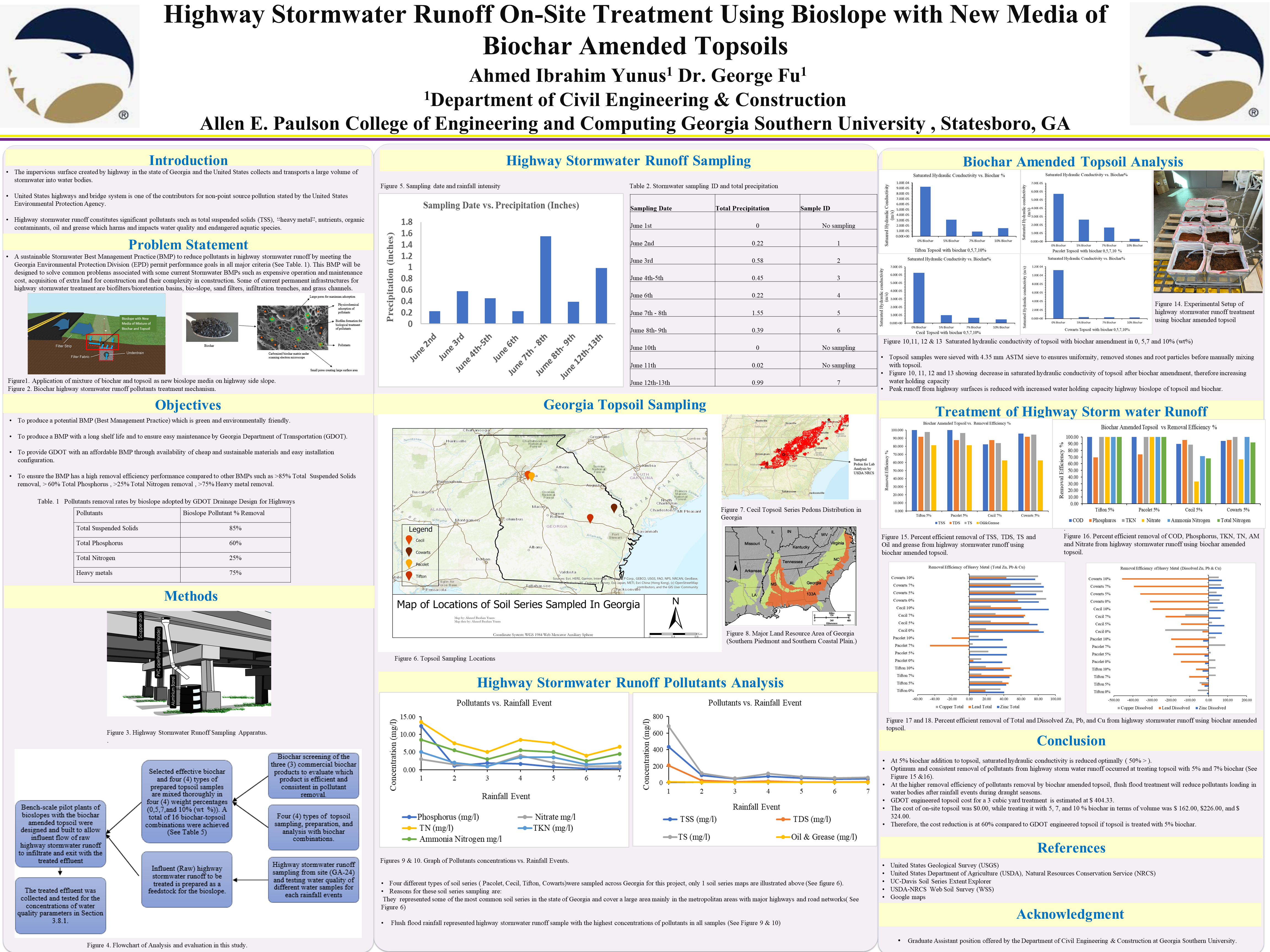
POSTER 18-09: HIGHWAY STORMWATER RUNOFF ON-SITE TREATMENT USING BIOSLOPE WITH NEW MEDIA OF BIOCHAR AMENDED TOPSOILS

HIGHWAY STORMWATER RUNOFF ON-SITE TREATMENT USING BIOSLOPE WITH NEW MEDIA OF BIOCHAR AMENDED TOPSOILS


PI: George Fu

Co-PI(s): 

Institution(s): Georgia Southern University


Abstract

Biochar is typically fabricated from wood biomass, which is readily available and cheaper to obtain in Georgia. This study explored a new media of mixture of biochar and topsoil for bioslope. In this study, four (4) topsoil series (Tifton, Cecil, Pacolet, and Cowarts) were sampled across Georgia, analyzed, and amended with 5, 7, and 10% (weight percent, wt %) biochar to treat highway stormwater runoff through infiltration. Three (3) biochar products from the established manufacturers were selected and screened based on their properties and treatment efficiencies. By utilizing biochar amended topsoil as a new bioslope media, the removal performances exceeded 80% for TSS, total dissolved solids (TDS), total solids (TS), and 60% for oil and grease, ammonia nitrogen, nitrate nitrogen, total Kjeldahl nitrogen (TKN), total nitrogen (TN), and phosphorus with only 5% biochar amendment to the topsoils. For a three (3) yd3 installation volume, 5% biochar amended topsoil was 60% less costly in terms of materials than the current GDOT engineered topsoil for bioslope. Bioslope of biochar amended topsoil will minimize the material cost in construction while providing a green and sustainable alternative compared to the current GDOT bioslope.

Please comment below with any statements or questions you may have. Also let GTI if you would be interested webinars or presentations on similar topics.

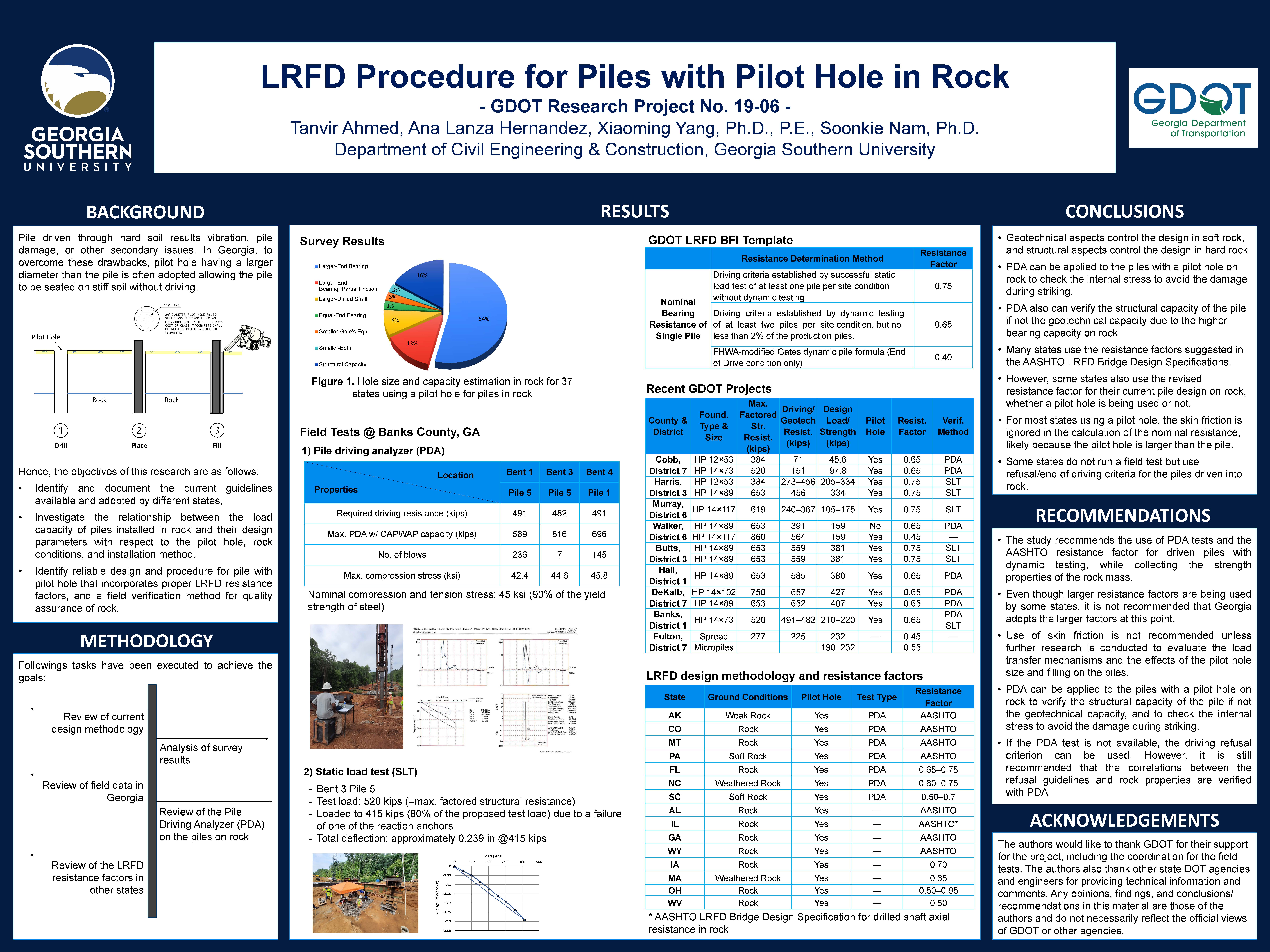
POSTER 19-06: LRFD PROCEDURE FOR PILES WITH PILOT HOLE IN ROCK

LRFD PROCEDURE FOR PILES WITH PILOT HOLE IN ROCK


PI: Soonkie Nam

Co-PI(s): Xiaoming Yang

Institution(s): Georgia Southern University


Abstract

In Georgia, when a hard/dense layer exists in the pile length or the vibration/noise during the driving causes secondary issues, a pilot hole is often adopted as a pile-driving assistance method to aid driving displacement piles through, especially if a competent hard rock layer exists in a reasonable depth. The use of a pilot hole reduces construction time and uncertainties related to driving through the problematic layers. However, the pilot hole is considered different from a pre-drilled hole in terms of construction method and design assumption. This process also complicates the prediction of long-term pile capacity with a predrilled hole. An objective of this study was to identify and document the current guidelines available and adopted by different states, and investigate the relationship between the load capacity of piles installed in rock and their design parameters with respect to the pilot hole, rock conditions, and installation method. Another objective was to identify a reliable design procedure that incorporates proper LRFD resistance factors, and a field verification method for quality assurance of rock. It is found that pile driving analyzer (PDA) can be applied to the piles with a pilot hole on rock and verify the structural capacity of the pile if not the geotechnical capacity due to the higher bearing capacity on rock. It also can check the internal stress to avoid the damage during striking. Thus, the study recommends the use of PDA tests and the AASHTO resistance factor for driven piles with dynamic testing, while collecting the strength properties of the rock mass. The driving refusal criterion can be used when the rock condition is evident. However, it is still recommended that the correlations between the refusal guidelines and rock properties are verified with PDA.


Please comment below with any statements or questions you may have. Also let GTI if you would be interested webinars or presentations on similar topics.

POSTER 19-10: FLASH TRACKING IMPLEMENTATION GUIDELINES COMPLEMENTING EXISTING DESIGN-BUILD MANUAL

FLASH TRACKING IMPLEMENTATION GUIDELINES COMPLEMENTING EXISTING DESIGN-BUILD MANUAL


PI: Pardis Pishdad-Bozorgi

Co-PI(s): Jesus M. de la Garza

Institution(s): Georgia Institute of Technology


Abstract

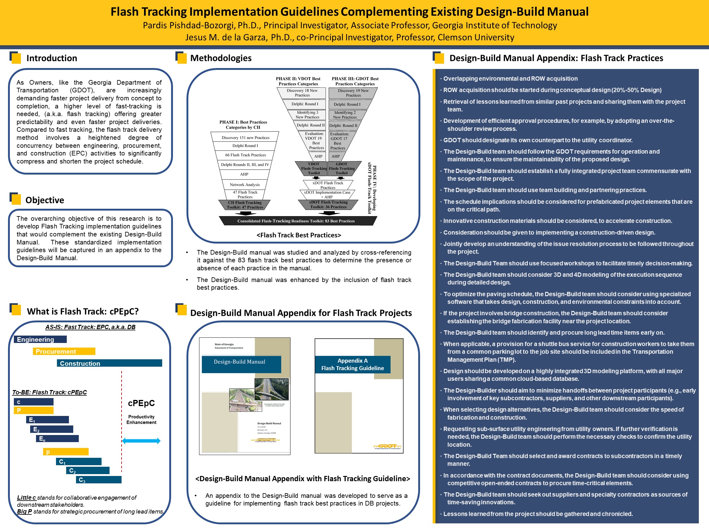
The overarching objective of this research is to develop Flash Tracking implementation guidelines that would complement the existing Design-Build Manual. These standardized implementation guidelines are captured in an appendix to the DesignBuild Manual. The research methodology comprised three phases. In the first phase, the research team studied and analyzed the effectiveness of flash track best practices implementation on three GDOT projects—namely, improvements to the I-16/I-95 interchange, the I-85 Widening, and SR 400 EL. In the second phase, the team reviewed and analyzed the GDOT DesignBuild Manual to identify its strengths, weaknesses, opportunities, and threats (i.e., a SWOT analysis) in terms of its treatment of flash track best practices. This involved cross-referencing the D-B manual against the 83 flash track best practices, to determine the presence or absence of each flash track best practice in the manual. In the third phase, an appendix to the D-B manual was developed to serve as an official source on implementing flash track best practices on D-B projects. Furthermore, modified RFQ and RFP templates were developed to incorporate flash track practices on projects and specific recommendations were made for the RFQ and RFP for the Houlihan Bridge P.I. No. 0013741/0013742 – SR 25 at Savannah & Middle River Bridges.


Please comment below with any statements or questions you may have. Also let GTI if you would be interested webinars or presentations on similar topics.
POSTER 20-04: WEIGHT-IN-MOTION (WIM) DATA SYNTHESIS & VALIDATION – DEEP LEARNING MODELS FOR VEHICLE CLASSIFICATIONPOSTER 20-04:

WEIGHT-IN-MOTION (WIM) DATA SYNTHESIS & VALIDATION – DEEP LEARNING MODELS FOR VEHICLE CLASSIFICATION


PI: Mi Geum Chorzepa

Co-PI(s): Jidong J. Yang, Stephan Durham, and Sonny Kim

Institution(s): University of Georgia


Abstract

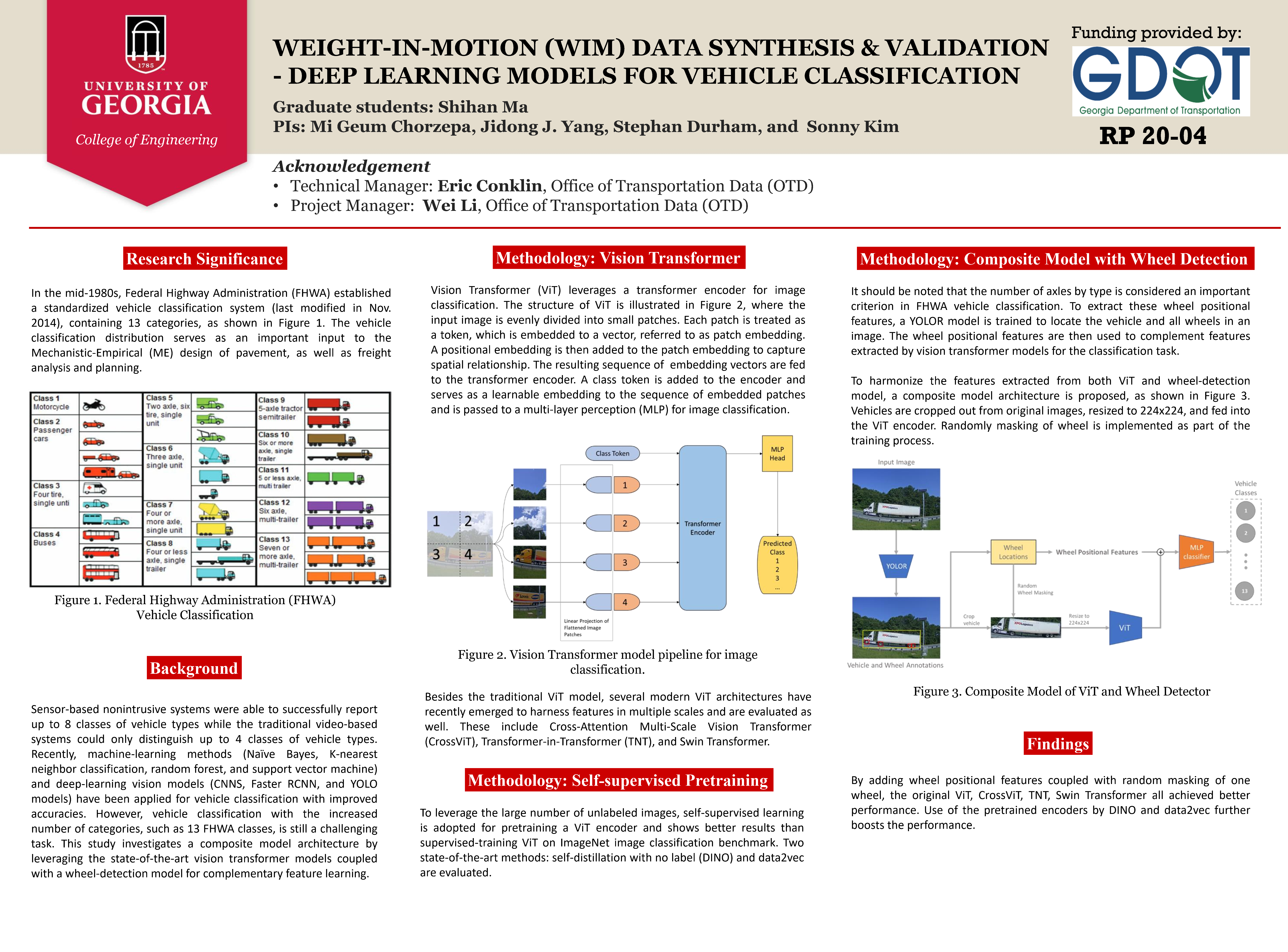
Sensor-based nonintrusive systems were able to successfully report up to 8 classes of vehicle types while the traditional video-based systems could only distinguish up to 4 classes of vehicle types. Recently, machine-learning methods (Naïve Bayes, K-nearest neighbor classification, random forest, and support vector machine) and deep-learning vision models (CNNS, Faster RCNN, and YOLO models) have been applied for vehicle classification with improved accuracies. However, vehicle classification with the increased number of categories, such as 13 FHWA classes, is still a challenging task. This study investigates a composite model architecture by leveraging the state-of-the-art vision transformer models coupled with a wheel-detection model for complementary feature learning.


Please comment below with any statements or questions you may have. Also let GTI if you would be interested webinars or presentations on similar topics.

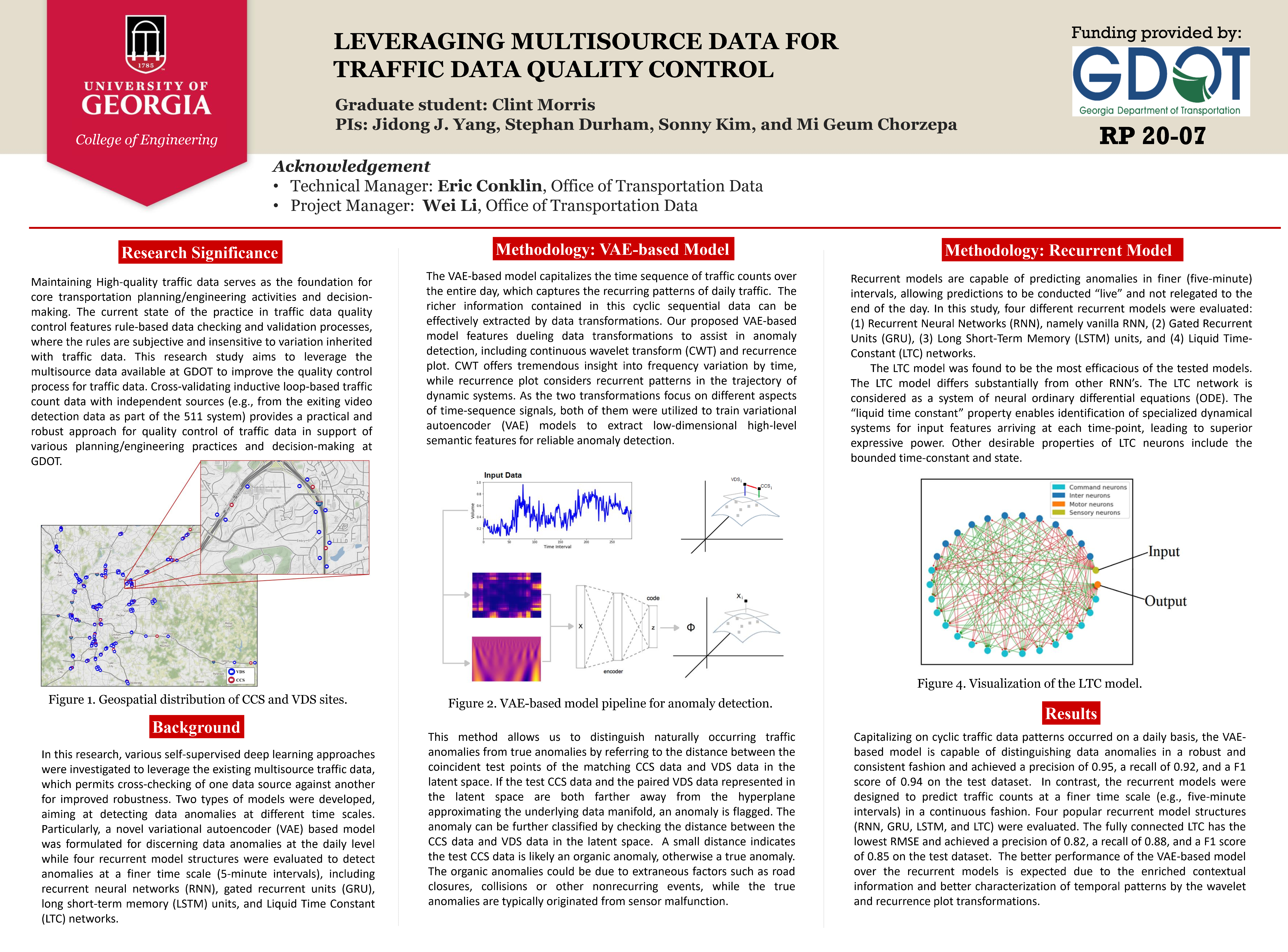
POSTER 20-07: LEVERAGING MULTISOURCE DATA FOR TRAFFIC DATA QUALITY CONTROL

LEVERAGING MULTISOURCE DATA FOR TRAFFIC DATA QUALITY CONTROL


PI: Jidong J. Yang

Co-PI(s): Stephan Durham, Sonny Kim, and Mi Geum Chorzepa

Institution(s): University of Georgia


Abstract

Maintaining High-quality traffic data serves as the foundation for core transportation planning/engineering activities and decisionmaking. The current state of the practice in traffic data quality control features rule-based data checking and validation processes, where the rules are subjective and insensitive to variation inherited with traffic data. This research study aims to leverage the multisource data available at GDOT to improve the quality control process for traffic data. Cross-validating inductive loop-based traffic count data with independent sources (e.g., from the exiting video detection data as part of the 511 system) provides a practical and robust approach for quality control of traffic data in support of various planning/engineering practices and decision-making at GDOT.


Please comment below with any statements or questions you may have. Also let GTI if you would be interested webinars or presentations on similar topics.
POSTER 20-20: TACIT KNOWLEDGE MODEL TO SUPPORT KNOWLEDGE CAPTURE AND TRANSFER IN GDOT

TACIT KNOWLEDGE MODEL TO SUPPORT KNOWLEDGE CAPTURE AND TRANSFER IN GDOT


PI: David A. Guerra-Zubiaga

Co-PI(s): 

Institution(s): Kennesaw State University


Abstract

Experiences from contractors, vendors, and internal GDOT staffs are often time lost because there is little mechanism for capturing experiences-tacit knowledge. This was how this project provide value to GDOT organization. The research bases on the idea that knowledge is an important intangible asset of any organization. Let’s take a step back and introduce two types of knowledge: Explicit Knowledge and Tacit Knowledge. Explicit can be described with words, instructions, and guidelines while tacit is more complex not only to identify but also to organize, capture and reuse for supporting key decision making. Tacit knowledge is based on the idea that people know more than what they can verbally express. This research concentrates on Tacit Knowledge Capture and Store using the experimental software. Moreover, GDOT and Kennesaw Research team are well aware that capturing, transferring, and maintaining skilled employees and contractors’ experiences is beneficial in terms of cost, efficiency, time, and efforts spend on special projects (i.e.: I-85 Bridge Collapse). The research team met with different GDOT offices, such as Office of Traffic Operations, Office of Bridge Maintenance, Bridge Construction, and Bridge Design to invent the instances (sketches, videos, patterns, and storytelling) of tacit knowledge and store them in the experimental software base on the Tacit Knowledge Model in which the KSU research team had defined previously. Tacit Knowledge Model is created based on Object Oriented Design and Programming using Unified Modeling Language (UML) notation. The team can reach its goal by (1) understanding previous GDOT knowledge management projects, (2) studying the I-85 bridge collapse case study (3) evaluating the findings and utilizing them at a specific GDOT department or area to consolidate specific benefits within that department or area via defined scenarios, (4) defining Tacit Knowledge Model and finally (4) developing a new tool with the potential of being implemented throughout the entire organization. •Keywords: Knowledge management, Tacit knowledge management, Explicit knowledge, Implicit knowledge, Tacit knowledge lifecycle, Tacit knowledge model.


Please comment below with any statements or questions you may have. Also let GTI if you would be interested webinars or presentations on similar topics.

POSTER 20-21: A FORECAST OF STATE MOTOR FUEL REVENUES: THE EFFECT OF NEW TECHNOLOGIES AND THE STATE VEHICLE FLEET MIX ON GEORGIA MOTOR FUEL RECEIP

A FORECAST OF STATE MOTOR FUEL REVENUES: THE EFFECT OF NEW TECHNOLOGIES AND THE STATE VEHICLE FLEET MIX ON GEORGIA MOTOR FUEL RECEIPTS


PI: Laura Wheeler

Co-PI(s): 

Institution(s): Georgia State University


Abstract

This display outlines the research on the impact of alternative fuel vehicles on the state motor fuel receipts and the development of a model to forecast motor fuel receipts.


Please comment below with any statements or questions you may have. Also let GTI if you would be interested webinars or presentations on similar topics.
POSTER 20-24: AERMOD, RLINE, AND RLINEXT CASE STUDY ANALYSES IN ATLANTA, GEORGIA

AERMOD, RLINE, AND RLINEXT CASE STUDY ANALYSES IN ATLANTA, GEORGIA


PI: Randall Guensler

Co-PI(s): Hongyu Lu, William Reichard, Ziyi Dai, Tian Xia, Angshuman Guin, Ph.D., and Michael O. Rodgers, Ph.D.

Institution(s): Georgia Institute of Technology


Abstract

This research assessed the impact of USEPA?s AERMOD dispersion model (version of 19191) source types on predicted pollutant concentrations via a case study for the I-75/I-575 Northwest Corridor (NWC) in Atlanta, GA. Using MOVES-Matrix for MOVES 2014b, carbon monoxide (CO) emissions rates for every hour of a one-year study period were generated using traffic volumes and speed from Atlanta Regional Commission’s Activity-Based Model (ABM) 2020 and AERMET meteorological profiles provided by the state environmental agency (EPD). To develop concentration profiles to assess prediction differences across source types, consistent input datasets for hourly emissions by ABM link, hourly AERMET data, and gridded receptor placement (standard 20-meter grids and variable grids after link-screening) were run with the AERMOD source types: AREAPOLY (manually created and automatically generated), LINE, VOLUME, RLINE, and RLINEXT (with and without noise barriers). The team processed more than one trillion source-receptor pairs the study area using the cyberinfrastructure resources provided by the Partnership for an Advanced Computing Environment (PACE) at Georgia Tech. The results indicate that predictions from AREAPOLY and LINE are essentially identical. Predictions from RLINE and RLINEXT are almost the same, but these predictions are higher in most cases than any other source type. The VOLUME source type always yields the lowest concentrations and is less sensitive to wind directions and speed, due to the embedded wind meander dispersion parameters implemented only for VOLUME sources. Machine learning results indicate that wind speed, receptor ID (which accounts for adjacent roads and their and their mass flux emission rates in grams/meter2/second), and wind direction influence the results much more than source type selection. Introducing noise barriers to RLINEXT lowered concentration as expected, but modeling barrier effects was challenging due to the restrictive assumptions in AERMOD. Sensitivity analysis for RLINEXT suggests that barrier height, distance to the roadway, wind speed, and wind direction all affect morel predictions. Modelers need to exercise care in matching barriers to roadway link segments (i.e., barrier edge effects were observed).


Please comment below with any statements or questions you may have. Also let GTI if you would be interested webinars or presentations on similar topics.

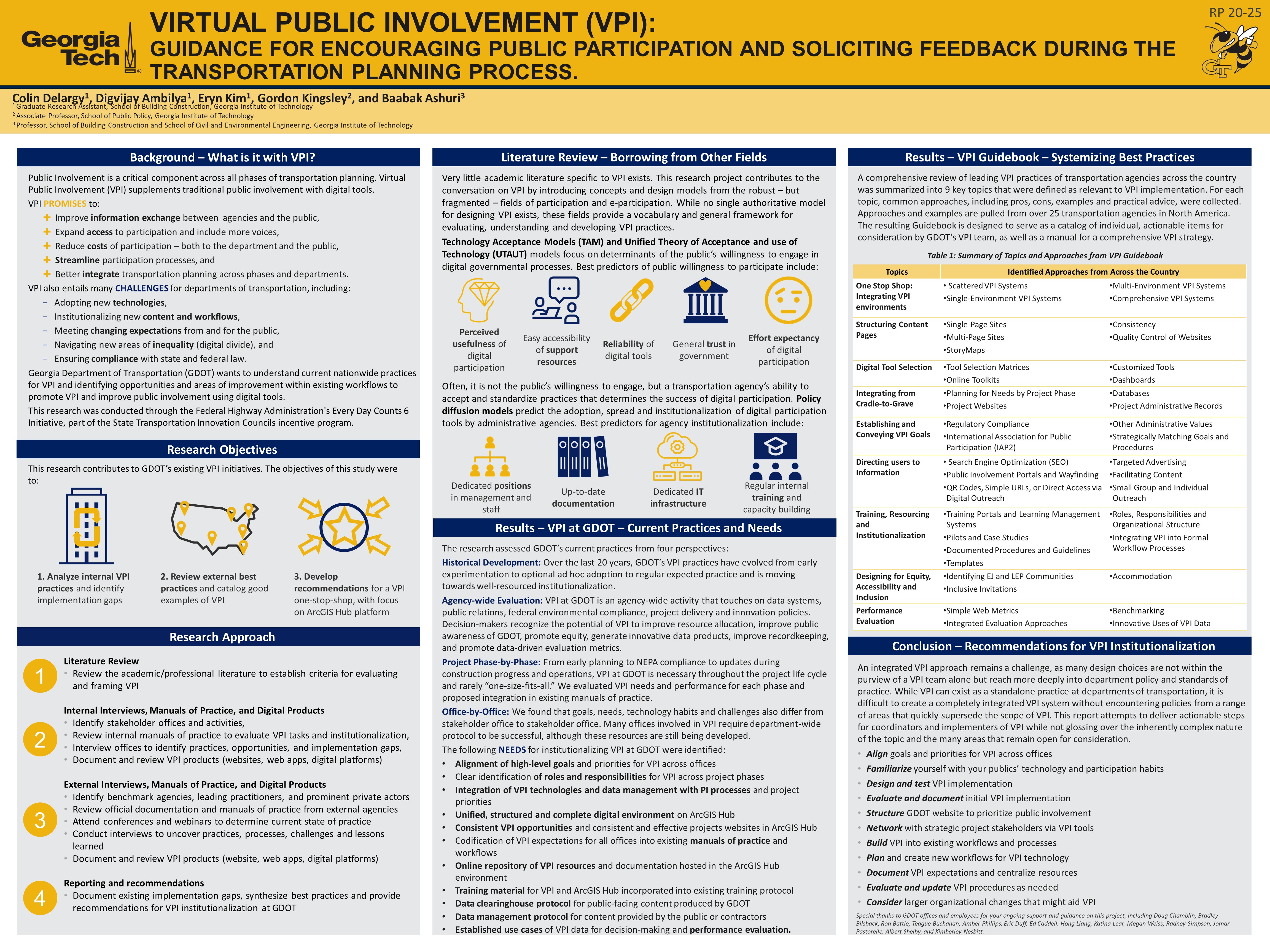
POSTER 20-25: VIRTUAL PUBLIC INVOLVEMENT (VPI): GUIDANCE FOR ENCOURAGING PUBLIC PARTICIPATION AND SOLICITING FEEDBACK DURING THE TRANSPORTATION PLANNING PROCESS

VIRTUAL PUBLIC INVOLVEMENT (VPI): GUIDANCE FOR ENCOURAGING PUBLIC PARTICIPATION AND SOLICITING FEEDBACK DURING THE TRANSPORTATION PLANNING PROCESS


PI: Baabak Ashuri

Co-PI(s): Gordon Kingsley

Institution(s): Georgia Institute of Technology


Abstract

In transportation planning and decision-making processes, public involvement (PI) is critical as the daily users of transportation share useful insights, opinions, and observations on the performance and needs of the transportation systems. Virtual Public Involvement (VPI) is the use of digital technology to engage individuals in project planning and decision making. It is intended to supplement face-to-face information sharing with virtual tools, and thus broaden existing approaches to public involvement to include more voices. The overarching objectives of this research were to gather and evaluate information on existing approaches to VPI and to provide recommendations for the development of a single-platform VPI environment on ArcGIS Hub that encourages widespread participation, facilitates two-way communication, and integrates VPI requirements into an inter- office, cradle-to-grave VPI process. The literature review provides examples of public participation design and key factors that contribute to the successful acceptance of VPI by the public. A review of GDOT practice identified the tasks, challenges, and goals for VPI by project phase and department and identified gaps in existing practice. A review of the community of practice was compiled to provide approaches to key tasks necessary for the design, implementation, and institutionalization of VPI across the country. Finally, 11 recommendations for institutionalizing VPI at GDOT were provided.


Please comment below with any statements or questions you may have. Also let GTI if you would be interested webinars or presentations on similar topics.